Climbing away from the valley on Lake Mountain's Bugs Bunny. Trail pics and review based on multiple rides by Bruce with latest update March 21, 2026.
Eagle Mountain - East Trails
Rock-a-Billy, Cow Tracks, Bugs Bunny, Jackrabbit, Roadrunner,
Rocket Powered Roller Skates, Hog Rider, Hunting Wabbit
Wile E Coyote, Cropduster, GunslingerThis trail page discusses the
trails on the west-facing slope of northern Lake Mountain within the
extensive Eagle Mountain trail system.
Note that a quick description of major Eagle Mountain trails
can be found on the
Eagle Mountain Overview Page.
Full descriptions of area trails are found on pages for the
northern Eagle Mountain trails, the
Eagle Mountain Race Loop, the
Mountain Ranch Bike Park, the
Lake Mountain East Ridgeline route, the
Hidden Valley Trailhead loops, the
Hickman Hill Practice loops, the
Treadstone-area (Prayer Flag hill) trails, and the
south Eagle Mountain trails.
The elevation of these trails ranges from a low of 5000 feet on the north side to a high of
5600 feet on the south. The area tends to stay dry, so Eagle Mountain
can often be biked in
the winter with a standard XC bike. It also dries quickly after storms,
and is the go-to bad-weather
ride for Utah County and Salt Lake County riders.

Bruce cruises on the Jackrabbit trail.

Typical stunt. On Rock-a-Billy, you can launch at speed to clear the entire downslope of the rock, or at lower speed follow the rock contour to do a simple drop from the far end.
There's currently around 30 miles of trail at Eagle Mountain, with more added yearly. Most
trails would be classified intermediate but can be easily done by an experienced
beginning
rider. A few trails have stunts such as ledge drops, ladders, and gap
jumps. (These have ride-arounds.)
There are countless riding options, as the trails branch and cross
over. There's no "best loop" here, although most riders consider
the ride incomplete if they don't hit the prayer flags at the top of the
knoll on
Treadstone
.

Parking lot, looking southeast.
Hidden HollowThe paved Hidden Hollow trailhead has a bathroom, water, and room for over 40 vehicles.
Westbound on SR-73 from Redwood Road (11600 West) in Lehi or from the
Mountain View Corridor, turn left at the stop light onto The Ranches Parkway.
At Pony Express Parkway, turn right. The road will veer a bit south
(left), then back west (right) as you get one mile from Ranches Parkway.
At the traffic light before Hidden Hollow
Elementary, turn left and drive uphill 0.3 miles. Turn left into the
parking lot.
Rock-a-Billy is the usual route to the trails of Lake Mountain. The entry is at the northeast (upper) corner of the parking area.
A doubletrack across the road to the west will take you to
the Hickman Hill loops (and to Supersonic, Cracker Jack, and Given-to-Fly
southbound, plus Creed and Brass Monkey northbound).

Looking down on the race staging area from Treadstone.
Rockpile race staging area
On Pony Express Parkway heading west, turn left to the Hidden Canyon road at 1.1 miles from
Ranches Parkway. Continue up the paved road until it turns into dirt.
Keep generally left and
heading southeast at any road forks, staying just below the slope of the
hill on your left.
When you reach a rockpile followed by a broad open area with several dirt
roads forking away
at mile 1.3 from Pony Express Parkway, you're there. The northern trails
are most easily reached
by taking Deer Tracks to Cracker Jack, just up the hill west of the staging
area.

Looking northeast from Hidden Canyon.
The Hidden Canyon trail starts at the northeastern corner of the Hidden Hollow parking area.
It climbs the hill to the area above the Mountain Ranch bike park, connecting
to Rock-a-Billy,
Ridgeline/Cow Tracks, and Golden Eagle. From the trailhead, there's an
initial stiff climb,
then a traverse around the north side of Lake Mountain toward the bike
park where there are
nice views to the north and east.
Hidden Canyon is 0.7 miles in length, with 200 feet of elevation change. There will be a couple
of man-made tech features to roll over (or roll around). The trail has
a few rock outcrops,
but overall it's intermediate in tech requirement. The grade on the initial
climb is 200 vertical
in 0.4 miles, which is very manageable by an intermediate rider.

View from Hidden Canyon as we pass above the homes of Eagle Mountain.

Climbing up from the intersection with Rock-a-Billy, heading for the bike park.
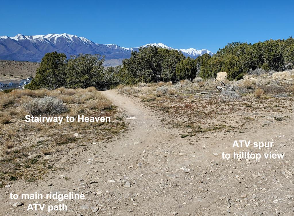
At the western end of the Hidden Canyon trail (also known as
Hidden Valley trail and as Ridgeline trail) there's a 5-way intersection
just before the trail reaches the paved trail near the elementary school.
In spring 2026, the trails are still unlabeled. Here's the layout if you
arrived from the bike park:
Trail going downhill northwest = continued Ridgeline (Hidden Canyon)
Hard right = Lookout Connector (dead-ends at gate above subdivision)
Medium left = Rock-a-Billy (from which you can catch Old Town Road)
Hard left = Stairway to Heaven (climb to top of trailhead DH rides)
And if you're climbing up Hidden Canyon the layout is left to right:
Lookout, Hidden Canyon, Stairway to Heaven, Rock-a-Billy.

Southbound early on Rock-a-Billy. Junipers occasionally obscure the sight lines, so be cautious about riders coming the other way!
Rock-a-Billy is the main north-south path for the northern half of Lake Mountain. It extends from the 5-way trail fork above Pony Express Parkway to (combined with Cow Tracks) the Rockpile race parking area.
Rock-a-Billy forks to the right (south) from western Hidden Canyon after 0.2
miles of fairly stiff climbing. It rolls up and down, but generally
climbs, as it traverses the western slope of Lake Mountain. The trail ends
on Cow Tracks just above the Rockpile trail parking area.
From the Hidden Canyon origin to its end on Cow Tracks, Rock-a-Billy is 1.1 miles long. From
north to south it gains 200 feet elevation, but with a climbing total
of 300 vertical feet.
The ride is easier-intermediate, with nicely banked turns and a few jumps
that you can ride
around. There will be nice views in both directions.

View south as little yellow flowers fill the meadows.

Looking north on Rock-a-Billy at the connector trail down to the parking lot (seen at far left).
Rock-a-Billy can also be reached from the paved Hidden Hollow trailhead via a short connector.
The connector splits 1/10th mile uphill from parking. Left takes you northbound
toward the
Hidden Canyon trail for a link to the bike park, while the right limb
joins Rock-a-Billy southbound
to Cow Tracks.
The middle portion of Rock-a-Billy splits into an uphill
branch (keep left if climbing), and a downhill branch (also keep
left if descending). The split section is 0.3 miles in length. The
marking can be a little hard to see (try to read the trail sign in the
photo), but the Lake Mountain Trails folk are placing new weatherproof
trail-post markers as quickly as they can.

Approaching the up/down trail split when climbing south.

The final grunt before joining Cow Tracks can be brutal.
After a bit of tough bumpy climbing, Rock-a-Billy joins Cow
Tracks for a combined route down to the Rockpile (race loop) parking. Keep
right at the intersection. As you hit ATV path, Bugs Bunny is straight
across. Veer to the right, cross the parking area, and find Deer Tracks if
you're hitting the Treadstone and Prayer Flags area.

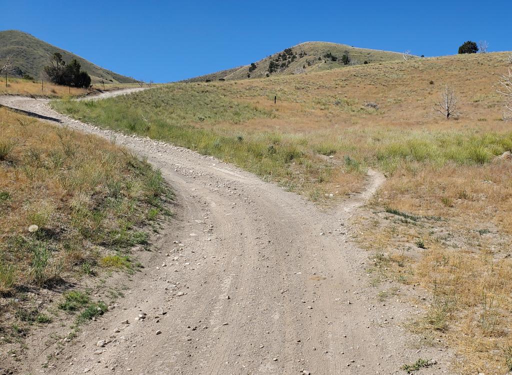
Approaching the Rock-around trail fork when southbound on Rock-a-Billy.
Rock-around is an alternate line off southbound
Rock-a-Billy. Because the trail fork is on the uphill-only side of the
split trail, you'll only see it if you're climbing. The fork is at mile
0.3 from the trail split, only 100 yards from where it rejoins the
descending trail. Rock-around rejoins Rock-a-Billy, so it doesn't take you
anywhere new. It's just an alternate.
In spring 2026, the fork is unmarked. Veer to the left uphill from
Rock-a-Billy to start Rock-around.
Rock-around is 0.2 miles in length. In tech difficulty it's
about equal to Rock-a-Billy.
Poon Panther joins Rock-around just before Rock-around rejoins
Rock-a-Billy. Don't try to climb up Poon Panther. It's a very steep
slippery DH trail that originated on the ATV track up on the ridgeline.
At the south end of Rock-around, merge onto Rock-a-Billy.

Typical trail on Rock-around.

Slippery and steep.
Poon Panther is a less-popular short DH trail that starts on
the ridgeline doubletrack at the top of the Lake Mountain ridge. You need
to ride the ATV track from a spot where it connects to bike trail (for
example, Stairway to Heaven) and find the DH trail when you pass by.
On the way down, Poon Panther will cross Cow Tracks. So if
you're OK with a short ride but not OK with an ATV ride, you can fork off
Cow Tracks to hit it.
The Panther is 0.2 miles long with a drop of 100 feet.

Looking back uphill from a spot where you can pick your limestone drop-off.

The entry bridge to Cow Tracks remind us that there's some slightly more tech riding ahead -- especially if you decide to do a little lap around the Ridgeline Flow trail.
When climbing Hidden Canyon, at mile 0.7 you'll cross a doubletrack.
100 feet later take the right fork,
then cross the doubletrack again, going over the wooden entry bridge.
You're now on the combined Ridgeline and Cow Tracks trail. Start climbing
southbound, then
after 0.2 miles keep right to stay on Cow
Tracks as Ridgeline climbs uphill. (You can also reach Cow
Tracks from the
Mountain
Ranch Bike Park
. See the map.)
Cow Tracks is 0.8 miles long, contouring the hillside on its way to the Rockpile parking area.
When southbound, the trail will get steep for a while, but it's still
a very ride-able pitch.
The rocks ride nicely, so a strong intermediate should have no problem
grinding right up. The
trail then levels out and rolls along the west face of the hill as you
head south. It joins
Rock-a-Billy as it descends to the east side of the Rockpile parking area.
To continue south on singletrack, take Bugs Bunny, just across the dirt road from the bottom
of Cow Tracks near the rockpile parking/staging area.

The steepest spot is the climb just before the Ridgeline trail fork. There's both embedded and loose rock, but it's very do-able.

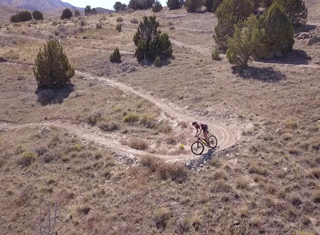
Climbing away from the rockpile parking on Bugs Bunny.
Bugs Bunny is a welcome singletrack route from the rockpile parking (event staging area) up
to the ridgeline of Lake Mountain. It then turns south to connect to the
doubletrack portion
of Jackrabbit known as Paintball City. Bugs Bunny is 0.6 miles in length,
with around 200 feetBugs Bunny is a welcome singletrack route from the
rockpile parking (event staging area) up to the ridgeline of Lake
Mountain. It then turns south to connect to the doubletrack portion of
Jackrabbit known as Paintball City, then on to the Flintstone viewpoint,
La Gringa, and Jackrabbit. Bugs Bunny is 1.0 miles in
length, with around 200 feet of climbing and 75 feet of descending when
done north to south.of climbing and 75 feet of descending when done north to south.
Bugs Bunny is an early-intermediate ride, with a bit of rock garden at the top of the ridge.
The trail winds back and forth when climbing uphill from the rockpile
parking, creating a gentle
overall rate of climb.

Getting up toward Lake Mountain's summit. Don't have to wait for great views -- they're already here.

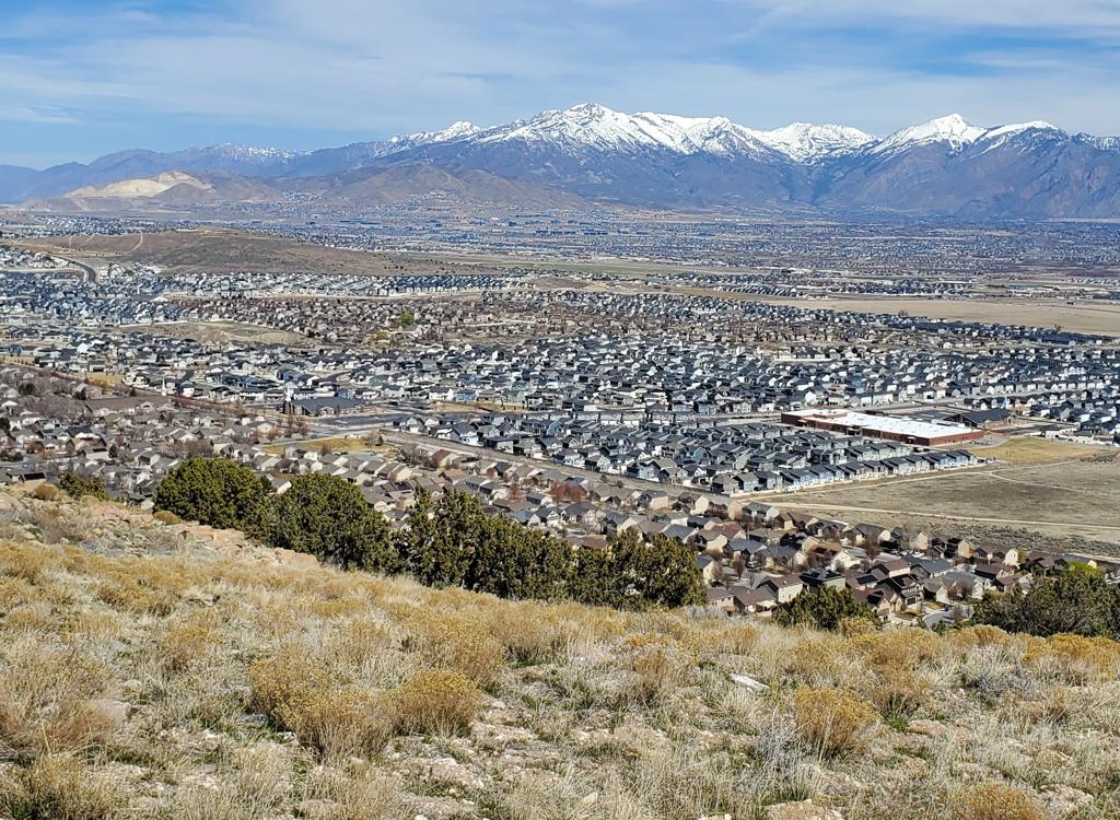
Reaching the summit of Lake Mountain, looking east toward Provo Peak, with Utah Lake on the far right.
Near the top of the ridge, Bugs Bunny offers a connection to Rocket Powered Roller Skates,
a directional trail that descends south to the north end of Roadrunner.
After crossing the
ridge (mile 0.4 from Cow Tracks) there's a trail split. These trails will
reconnect. To the
left is a downhill route, while the main trail keeps right.
At the very tip-top of the ridge, you'll hit
a rock garden. To your left is the main entry to the Apollo trail.
(There's another connector about 1/4 mile further on Bugs Bunny.) Just a
few more feet down the trail is the top of Roadrunner on your right.

We're approaching the top. When you see these rocks, you're approaching the fork with Apollo and Roadrunner.

View from Bugs Bunny of Utah Lake and the Wasatch Front above Utah Valley.
Bugs Bunny curves around to go southbound on the eastern
side of the ridgeline. The Apollo Connector will join on your right, then
you'll skirt a viewpoint at the north end of Paintball City. This is your
half-way point for Bugs Bunny, at mile 0.5.
Bugs Bunny will descends a bit through grassy meadows and an
occasional grove of juniper. Then it climbs and winds around a little.
From the viewpoint, it's another 0.5 miles to the end.
There's a short connector over to Flintstone on the left and to Hunting
Wabbit on the right.

The trail is smooth and non-technical through this section.

Standing on the Flintstone dirt road while looking down the Paintball City ATV path. Bugs Bunny is the singletrack, with La Gringa out-of-frame to our right.
When Bugs Bunny again hits the top of the ridgeline, it
parallels the doubletrack of Paintball City before arriving at the gravel
road to Flintstone.
There's a 90-degree left turn of the singletrack on the edge of the
intersection of the two roads. La Gringa is the trail to the left.
Flintstone can be found across the broad torn-up area of the viewpoint.
Jackrabbit is straight ahead across the road. Paintball City is the
doubletrack 180 degrees behind you. Hunting Wabbit forks left form
Paintball City after about 100 feet. Hog Rider forks downhill from the
road intersection area. Good luck! In spring 2026, only Jackrabbit is
marked.
Rocket Powered Roller Skates

Standing on Bugs Bunny, looking down RPRS.
Rocket Powered Roller Skates is a one-way downhill-only
trail that forks away from upper Bugs Bunny and descends to a doubletrack
right where Roadrunner crosses. (From the DT, you can take Roadrunner
either uphill or down.)
Rocket Powered Roller Skates is an easy trail, 0.2 miles in
length. There's only one tech spot (which you can simply ride around)
where you can select a rock slab of appropriate height to drop off.

Here's the one and only tech feature. The central drop is only about 18 inches.

Entry to Hunting Wabbit on the left. We're looking north.
Hunting Wabbit starts on the Paintball City doubletrack near
the end of Bugs Bunny and curves around the ridge area before ending on
Road Runner.
It's 0.4 miles long and is a very easy ride with no technical features.
On the way, it crosses and re-crosses the doubletrack, so that it passes
close to the overlook at the north end of Paintball City. Stay left to
avoid winding up on a torn-up viewpoint party zone.
Hunting Wabbit ends on Road Runner at the same spot as Hog
Rider.

Winding through a juniper grove on the ridgeline.

Bottom of Hog Rider on Roadrunner.
Hog Rider winds through the area between Paintball City and
Road Runner. It's 0.4 miles in length, with only a bit over 50 feet of
elevation change from top to bottom.

We're on Bugs Bunny, about to descend upper Road Runner.
Road Runner is 1.1 miles long, running from
trail fork between Bugs Bunny and Apollo down to Wile E Coyote before
ending on a broad dirt road.
To descend Road Runner, fork right from the top of Bugs
Bunny. Descend 0.3 miles to cross a doubletrack. You'll notice a trail on
your right coming from the same direction, which is Rocket Powered Roller
Skates. (Don't go there.)
Cross the doubletrack to continue downhill on Road Runner.
hortly after the doubletrack crossing, Hunting Wabbit and
Hog Rider will join on your left from uphill. Stay straight and downhill
on Road Runner.
Road Runner will cross another dirt road (the DT up to Flintstone) at
mile 0.6, then will quickly cross Crop Duster then Gunslinger.
The next trail fork, at mile 1.0 from the top, is Wile E Coyote on your
left. If you continue descending to mile 1.1, it will drop you onto the
main dirt road between hillside and valley. Going northbound here will
take you to the Rockpile (race staging) parking area.

We're passing through a juniper grove on Road Runner
 segment of Rod Runner.")
On the way uphill, we're crossing the doubletrack for the final (newer) segment of Rod Runner.
Many riders start from the dirt road at the bottom of Road
Runner, because this is the path for the race loop. Head south down the valley from the Rockpile on
dirt road 0.3
miles to turn left on the Road Runner singletrack.
Wile E Coyote will fork to the right (southbound) just
1/10th mile uphill. Further on, Road Runner will cross both Cropduster and
Gunslinger, then a gravel road at mile 0.5 as it heads northbound.
Road Runner will turn back northbound as climbs gently. At mile 0.7,
Hunting Wabbit and Hog Rider are uphill on your right. Keep straight. Now
you'll reach doubletrack. Cross over and take the right-hand trail, which
is upper Road Runner. Your next stop will be Bugs Bunny on the ridgeline.

Much of Road Runner is straight and fast.
Jackrabbit (includes Paintball City doubletrack section)

Finding our way through the junipers. The race-day markers won't be there when you ride, so just keep meandering south.
Jackrabbit starts high on the ridgeline, about 0.3 miles from the Rockpile and 0.1 mile from
the top of Roadrunner. Jackrabbit is 1.4 miles long with almost no overall
elevation change,
but with a fair amount of up-and-down. The first portion of Jackrabbit
follows (approximately)
the ridgeline ATV route southbound. This stretch is also called Paintball
City. It's a bit
of a maze through the trees, as every clearing seems to have branching
tracks. Just keep heading
south on what appears to be the main path. The interweaving tracks should
rejoin before you
hit the singletrack.
You'll emerge from the trees to cross a doubletrack (FYI, this doubletrack is the route to
Flintstone
). Now you're on Jackrabbit proper, a narrow winding non-motorized singletrack.
The scenery is inspiringly desolate and has its own ugly Great Basin type of empty beauty.
There's plenty of very nice riding surrounded by a unique landscape. Jackrabbit
will cross
Cropduster, Gunslinger, then Wile E Coyote before it connects to Deadwood.

Looking south as we enter Jackrabbit. The sign says "no motorized vehicles."

View back to the north at the Oquirrh Mountains.
The scenery is inspiringly desolate and has its own ugly Great Basin
type of empty beauty. There's plenty of very nice riding surrounded by a
unique landscape. Jackrabbit will cross Cropduster, Gunslinger, then Wile
E Coyote before it connects to Deadwood.
At the southern end, 1.4 miles from the ridgeline,
Jackrabbit drops rapidly through a series of smooth banked turns. Jackrabbit
will cross the Wile E Coyote singletrack shortly before joining a
doubletrack on the edge of the valley.

Rolling a tight banked turn as we descend to the dirt road.

Cruising Jackrabbit.
If you're heading for Deadwood, you
can either turn left onto Wile E Coyote, or drop down to the dirt road. If
you go for the road, keep left and heading south to reach Deadwood. Take a
right on the dirt road at the road fork, then left on singletrack.

View back to the north at the Oquirrh Mountains as Bruce rides Wile E Coyote.
As mentioned above, Wile E Coyote forks away from Roadrunner just 150 yards from its southern
end. From the origin on Roadrunner the trail runs south 0.9 miles before
ending at a dirt-road
fork just across from the southern end of Deadwood. (To connect to Deadwood,
follow the doubletrack
around to the right so you're heading northwest. Spot the singletrack
on your left after around
50 yards.)
When ridden north to south, Wile E Coyote is generally uphill, but has some up-and-down that
make it a bit tougher. It's a much harder bit of riding than the doubletrack.
While it gains
only 150 feet in absolute altitude as you progress south, the rolling
hillside makes it seem
like more.

A bit of late spring snow persists under the cedars on Wile E Coyote.

Shortly after forking onto Cropduster from Backspacer, we're heading southeast along the ravine.
Cropduster forks away from Backspacer as southbound Backspacer crosses a dirt road. Veer to
the left and turn east along the edge of the ravine. Cropduster will give
you a gentle but
sustained climb to the top of the ridge on Lake Mountain. It's 1.3 miles
in length with 300
feet of elevation gain.
The trail surface is fairly smooth, but there are a few jumps built in. Although most riders
use Cropduster as a climber, it's a two-way trail and you can expect to
encounter riders going
the other way at high speed. Downhillers, stop and move aside for climbers!
At mile 0.7 from Backspacer, you'll reach a trail fork. Cropduster goes left. The right fork
is Gunslinger.

A gap jump on Cropduster, for riders who are descending. Note the prominent ride-around.

The Oquirrh Mountains make a beautiful backdrop for Cropduster.
Cropduster will cross both Roadrunner and Jackrabbit on its way to the top. It ends at a dirt
road on the ridgeline at around 5450 feet elevation. Across the road is
the Shooting Gallery
trail, which is CLOSED. (Unsafe conditions due to poorly-controlled illegal
shooting on a daily
basis.)

Gunslinger heads west across the ridge at the fork with Cropduster.
As a downhill, Gunslinger starts right where Cropduster ends. The trail drops to the west before
turning back north to rejoin Cropduster 0.5 miles later. The vertical
drop is 200 feet.
Turns are banked and the riding is fairly easy. There are a few engineered jumps that intermediate
riders can simply go around.
While most riders use Gunslinger as a downhill, it's a two-way trail. So yield to climbers
on your way down.

Heading north during the descent.

Riding north on Apollo in mid-March 2026, with a bit of snow on the Oquirrh Mountains ahead.
Apollo
Apollo is the northernmost piece of the eastern ridgeline
ride. It's a two-way trail although most riders will prefer to ride
northbound.
Apollo has the most slope of the three ridgeline trails, but drops only
100 vertical feet in 0.7 miles when done south to north. However most of
that slope comes in a short stretch that will be a tough climb when the
trail is dusty. So for both tech difficulty and navigation simplicity, I
suggest riding it from the southern end northbound. Because of these
steeper bits, I rate Apollo as intermediate.
Apollo is discussed in detail on the Eastern
Ridge page.

Running along the ridge on La Gringa, enjoying a view of Utah Valley.
La Gringa
La Gringa is the southernmost of the Lake Mountain ridgeline
trails. It's 0.6 miles long with 100 vertical feet of elevation loss from
south to north. There's a series of limestone rock outcrops near the
southern end that might challenge less-strong riders coming from the
north, but they're do-able. The outcrops raise the overall tech rating for
La Gringa to intermediate, but the rest of the trail is quite easy.
La Gringa is discussed in detail on the Eastern
Ridge page.

Traversing west on the first section of Deadwood.
DeadwoodDeadwood is discussed on the
Eagle
Mountain South Trails
page, but is mentioned here
because it connects to the southern end of Wile E Coyote.
Deadwood climbs away from the road heading westbound. After
it skirts the low hill at the southern end of Hidden Valley, it will drop
down and cross a dirt road. It will climb a bit up the opposite hillside
before turn north. Deadwood ends on dirt road across from the southwestern
end of
Treadstone
(discussed on the
Eagle
Mountain Middle Trails
page).

Climbing the hill.
411, Eastwood, and Fistful of DollarsNew in 2020
is a cluster of trails at the south end of the Deadwood Trail. It
features a climbing trail called 411 and two flow trails called Eastwood
and Fistful of Dollars. These trails are discussed in detail on the
South
Eagle Mountain trail page
.
411 begins on the doubletrack that
heads uphill from the south end of Deadwood. Pedal just over 1/10th mile
on the doubletrack then turn right onto the climbing singletrack. You'll
cross Eastwood on the way uphill, then reach the top of Eastwood at mile
0.6. Turn left to drop Eastwood, or continue straight uphill for Fistful
of Dollars.

Looking east as we approach a diving board.
FlintstoneThis is a downhill-only expert trail with some high-expert
options. It starts on the east ridgeline above the DH trails and descends
to dirt road in southern Eagle Mountain. Most riders do this with a
shuttle vehicle. The top of the trail is up a DT from the middle of
Jackrabbit or Roadrunner.
See the Flintstone page
.
(Note: the nearby Shooting Gallery trail remains closed!)