
Just one of the many ramps in the skills park. Photos and review December 1, 2009 by Bruce. Updated map information August 2015.
Note that since this review, some of the trail names have been altered, and many of the stunts
have been rebuilt. One constant feature of Eagle Mountain is that things
keep changing. The
last major re-build for the bike park was in 2021. The riding ranges from
beginner on 110 Trail
to double-black diamond on the Ridgeline Flow. Most climbs are broken
up and not too tough.
The climb up Ridgeline Trail at the top of the trail system is quite strenuous.
You can pick
the type of riding you're up for.

A banked turn on Ridgeline Flow.

Ramp route incorporates a rock tabletop. Ride over it, or take a wheelie-drop. Or do rock-to-rock hopping, hop onto a rock, and other trials stuff.
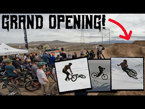
The park is located on the south end of The Ranches in east Eagle Mountain, where the power
line corridor hits the mountain. The skills park, pump track, and jump
lines lie under the
power lines on a very gentle slope. The XC and DH trails are on the juniper-covered
hillside
to the south.
The skills area offers a dozen ramps of varying difficulty, from beginner to expert. It includes
some drop-offs. There's an area with large flat-top rocks for trials hops.
There are picnic tables in the area where family members can hang out.

The 220 and Juniper trails end at the skills park. We're looking southwest over the last jump of the DH trail, with a corner of the skills area in the background.

Looking south, we're seeing about 1/4 of the pump track area.
Just south of the skills area is the pump track. It's a large track with multiple riding lines
through bumps and semi-circle banks. If you don't know what a pump track
is for, show up on
a Saturday and ask somebody to teach you.
Depending on the snow situation, you can ride this area much of the winter. Ride only when
the ground is dry or frozen. Please don't rut the dirt when the surface
is muddy!

The jump line, seen in the upper right, connects to the pump track. Note the temporary bathroom facility behind the jumps.
 launches on the jump line. Photo courtesy of Randy Klein...")
Alex Rodriguez (age 13) launches on the jump line. Photo courtesy of Randy Klein, April 2011.
South of the pump track along the power-line corridor is a jump line. You can pedal directly
to the top of the jump line, or hit it by forking off the 220 Trail during
your descent.
The DH trails cover the mountainside south of the stunt areas. The area is designed to be ridden
counter-clockwise. Access to the DH trails is via a broad cindered path
that goes gently uphill
along the west border of the park. (This trail is a continuation of the
trail you rode from
the kiosk to the stunt area.)

Typical view of the hillside trails. The routes twist through the juniper with occasional rock outcrops.

Alex Rodriguez takes one of the jumping ramps on the many trails. Photo Randy Klein 2011.
The hillside trails were built with the idea that riders will be doing small loops -- uphill
to the far south end, then pick a route that will put you back at the
bottom.
The trails tend to be a combination of relatively long traverse sections with up and down riding,
then downhill plunges with banked turns built for speed. I lost count
of the number of jumps
and technical features. For the intermediate rider, there are ride-arounds
past most of the
tech stuff on the lower mountain. Some wooden features, such as those
on the Ridgeline Flow
trail, have no ride-arounds and are do-or-die.

Higher on the mountain, we're heading north on the Golden Eagle Trail.

View of Timpanogos and Cascade Mountain to the east, from Golden Eagle.
Newer trails have created tougher and longer ride options. It can be confusing for the first-timer,
with multiple unmarked trail forks. A GPS navigation aid is recommended.
Expect to put in a
few miles getting acquainted.In general, the more difficult trails are
found higher on the mountain.

A rocky outcrop on the Ridgeline trail.
110 Loop
110, 220, under the power lines. Voltage. Get it? 110
is an easy cruiser for beginners. Offers practice at bermed turns and
little dirt hops for intermediates.
0.0 From the west side of the skills area,
ride uphill southwest on the cinder
path
0.3 Fork L on gravel DT
50 feet later, fork L on ST downhill
0.7 Back to skills area

Jackie trots behind the bike. We put in 8 miles to catch all the mountainside trails in 2009. There are many more miles of trail now.

At the trail fork, this is the ramp to the drop-in on 220.
220 Loop
220 has a spooky drop-in, then flies down to dirt jumps.
The drop-in has no obvious ride-around, and is designed to keep people
like me off this trail so we're not in the way of the big-air guys.
0.0 Uphill on cinder path as above
0.3 Fork L on gravel DT, keep straight past 110 entry
0.4 As DT turns R and west, find ST on your L
50 feet later, fork L, climb 100 feet
north
At 220/Juniper fork, go L over drop
0.7 R to join Juniper (L for jump line)
0.8 Join Juniper
0.9 Drop into Skills Park
Juniper Loop
Good stuff. Stunts and drops.
0.0 Uphill on cinder path as above
0.3 Fork L on gravel DT, keep straight past 110 entry
0.4 As DT turns R and west, find ST on your L
50 feet later, fork L, climb
100 feet north
At 220/Juniper fork, keep
straight
0.45 Either way (L=easier)
0.5 Keep R uphill (L=cruiser)
0.6 L downhill
0.7 Trails rejoin
0.85 220 joins on L
1.0 Drop into Skills Park

Stunt on the Juniper Trail. This one spooked me. Wood-o-phobia.

Teeter on the Juniper Trail.
Golden Eagle Loop
Ridgeline. More of an XC flavor. Some unfinished business
here. Connections and forks will likely change in the future.
0.0 Uphill on cinder path as above
0.3 Fork L on gravel DT, keep straight past 110 entry
0.4 As DT turns R and west, find ST on your L
50 feet later, fork R and climb
up the hill
0.6 Fork L
(R=to unfinished trail SW and DT
to Flintstone trail)
0.8 Keep straight (uphill) at 2 forks
1.0 Trail turns 180 -- foot trail forks off on R
1.2 R downhill to join Juniper
1.6 At skills park
Note that the above trail directions will become outdated as the
trail system evolves.
Bottom line:
Nice bike park, still one of the best in the state. Very nice trail system
with its own rugged beauty. Good option for early- or late-season
riding!

View of the jump line.

Map of the bike park area.
Getting there: Take the I-15 Lehi Main Street
exit and turn west. Continue west on SR-73, crossing Redwood Road (11600
West). Just after climbing the hill, turn left at the stop light onto The
Ranches Parkway. Stay on that road as it narrows and begins to wind
around. When you come to a T intersection at the end of The Ranches
Parkway, turn right on Golden Eagle Road. Drive about 1/3 mile and watch
for the trail kiosk on your left. Park by the trail kiosk and begin your
ride by climbing up the trail heading south.
Bathrooms: port-a-potty near jump line, BR in city
park west of trail head
Picnic tables and trash cans in skills and pump track areas.


 launches on the jump line. Photo courtesy of Randy Klein...")


