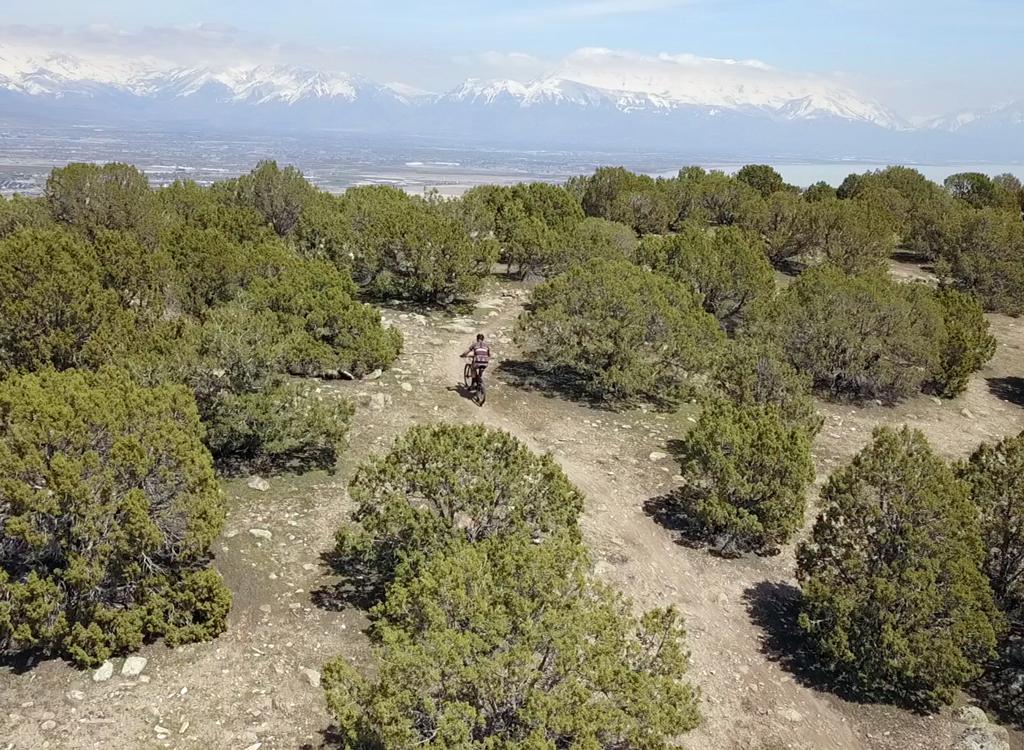
Looking southeast while riding the loop clockwise. That's Mount Timpanogos in Utah County at mid-right.
Beware Of DougThe Beware of Doug loop, new in 2024, has the honor of being the
highest-elevation trail in the Corner Canyon and Traverse Mountain
systems. Because of its location, you'll have views of both Salt Lake
Valley and Utah Valley, as well as the surrounding mountains.
The Beware of Doug trail is a lariat, with singletrack starting on the
gravel Deer Ridge road and climbing to a loop at the top.
Initial review and photos September 30, 2024 by Bruce. Updated July 2025 to include the singletrack connector trail to the loop.
The singletrack "stem" is 0.4 miles long. It
reaches the lowest-elevation spot on the loop at 6350 feet. The loop is two-way, 0.9 miles in length.
Most riders will go clockwise. The top of the loop intersects the
old Deer Ridge gravel doubletrack at the top elevation of 6450 feet. The expected riding season will be
late May through October.
Beware of Doug lies within Draper's "off-leash" area for
dogs. If your pup is trained to stay with you on the trail, you can take
Fido along for your ride.

Looking west as the loop crosses doubletrack at the ride's highest point. The trail is marked with wooden signs as seen here.

Looking south on doubletrack. This is on the climb up Dry Canyon from the Bonneville Shoreline Trail in Lehi.
Many riders use the doubletrack between the Deer Ridge trailhead and the top of Mayor's Trail as part of a loop ride that includes western Ann's Trail, Traverse Traverse,
and Mayors Trail -- or some other ride that combines the trail systems of Draper and Traverse Mountain. The Beware of Doug trail can substitute for part of that gravel road, or can be a side dish as you pass through.
The trail is machine-built on a hillside covered in gambel
oak. There are frequent breakout views. The grade is gentle. The trail
surface is suitable for beginners. Although there's a hiking-only trail
that makes the same circuit around the hill, you'll find a lot of foot
traffic on Beware of Doug.

Looking north over the Salt Lake Valley as the trail curves around the hillside.

View east toward Lone Peak and Suncrest from the southern side of the loop.
You can get to the loop from either Draper's Corner Canyon
trail system, or from Traverse Mountain's trails. A lot of riders are now
inserting a loop-de-loop around Beware of Doug into a longer loop ride
through the area's trails.
Trailheads and accessFox Canyon trailhead in Traverse Mountain

Looking west from the trailhead parking lot. The access trail turns around 180 degrees as it starts uphill.
The main access point for those who drive to the Traverse Mountain trails
is the new paved trailhead in Fox Canyon. Turn onto the Fox Canyon road
and drive to the top of the pavement. There's parking for around 20
vehicles, with a toilet and other amenities planned. The trail entry is on
the northern wing of the parking complex. At the northwest corner, find a
paved strip leading uphill to a dirt doubletrack (which then turns to the
right uphill).
Follow the dirt road 100 yards uphill to where the Sensei
trail crosses. Depending on your ride plan, you can reach Mayors trail in
either direction by connecting via Sensei then either Mo-mentum and
Traverse Traverse, or via Sensei south and westbound to Lolo's. See below
for additional navigation instruction.
Via Sensei, Lolo's, and Mayors Trail using Deer Ridge Doubletrack

Looking north as we leave Mayor's Trail to head for Beware of Doug.
From the Fox Canyon trailhead, climb south on Sensei to
Lolo's. When you reach Lolo's highest point, turn hard left onto Mayors
Trail. At mile 3.5 and 900 vertical feet from the trailhead, you'll reach
a trail fork where Lehi's Dream forks away to the left and Mayors trail
turns downhill. Veer slightly to your right to get up onto the doubletrack
and head northeast around the gate.
After 1/4 mile of gentle climbing, keep straight and to the right to
pass the Deer Ridge Road on your left. Keep straight as a DT spur heads
uphill on your right. At mile 0.3, Beware of Doug crosses the doubletrack.
Go either way. (The trail sign that you can see 100 yards further east is
a hiking-only trail.)
Via Ann's Trail from Deer Ridge (or upper Maple Hollow) trailhead

Looking west in the Deer Ridge trailhead parking strip.
Get onto Deer Ridge Drive at the top of Suncrest. Drive west for just
under one mile. As you reach Deer Ridge trailhead, keep straight into the
parking area. This trailhead includes bathrooms, water, and other
resources. (Alternate: Turn to the right at Elk Glen Drive as you reach
the trailhead sign, then turn left into the Maple Hollow trailhead parking
area.)
Go north on the singletrack at the picnic table on the edge of the
parking strip. At the Maple Hollow trailhead, turn left, then left again,
then left again onto Ann's Connector. In 1.1 miles, turn left onto Ann's trail
and pedal 0.9 miles to the trail fork for
Traverse Traverse.
Turn uphill and ride the "wiggles" up to the top of the ridge.
At mile 1.3 from the trail fork, you'll reach a doubletrack on a
ridgeline. Cross over, then turn to the left onto Mayors trail. Climb 1.6
miles to the top, then turn hard left onto doubletrack heading northeast. Pedal 0.6 miles to the loop.
Via Deer Ridge doubletrack and singletrack Beware of Doug connector from Deer Ridge trailhead

Looking uphill on Deer Ridge doubletrack at the edge of the trailhead. Note the water-bottle filler and bike-washing stations!
At the
stop sign in Suncrest, get on Deer Ridge Drive (right turn from SLC,
straight from Utah Co). Go 0.9 miles and enter the Deer Ridge trailhead.
After parking, pedal uphill to the far west end of the trailhead. Begin
your climb uphill on the wide gravel road. After 0.4 miles, turn left on a
singletrack and
climb another 0.4 miles uphill to where the bottom side of the Beware of Doug loop crosses.
If you need to park at the Maple Hollow trailhead, you can catch the Highland Connector singletrack
to connect over to Deer Ridge. On the singletrack, first turn left (south)
for 50 feet, then fork right. The sign at this trail fork says Telegraph
Trail, but this is NOT the hiking-only part. This trail will take you 1/10th
mile south to the Deer Ridge trailhead, where you'll turn to the right uphill.
(If you hit an underpass, you're on the South Maple Hollow trail. Go back
and try again.)
Via Bonneville Shoreline and Dry Canyon road

View into Dry Canyon from the BST.
On the Bonneville Shoreline Trail 1.8 mile from the
Brookside (lower Maple Hollow) trailhead, or 0.4 miles from 400 East
parking, turn uphill on the doubletrack Dry Canyon road. It will become a
grunt, rising 800 vertical feet in 1.2 miles. (Most riders who use this DT
will make it the downhill limb of a loop ride.)
As you reach a wide saddle area, you'll join a doubletrack with the
Mayors Trail and Lehi's Dream on the other side. Turn to the right
on the doubletrack. Go around the gate to begin climbing toward Beware of
Doug.
After 1/4 mile of gentle climbing, keep straight and to the right to
pass the Deer Ridge Road on your left. Keep straight as a DT spur heads
uphill on your right. At mile 0.3, Beware of Doug crosses the doubletrack.
Go either way. (The trail sign that you can see 100 yards further east is
a hiking-only trail.)
Beware of Doug connector trail

Riding west toward Beware of Doug. A singletrack runs alongside the gravel road for part of the way.
The "stem" of Beware of Doug is reached via the
gravel Deer Ridge road. (The road is closed to public vehicles, so you'll
encounter only bikes, hikers, and dogs on the road.) From the Deer Ridge
trailhead, pedal 0.4 miles uphill. On some sections of the road, a small
singletrack runs parallel. The first bit of the road above the trailhead
is kinda steep, then it mellow out. Overall, you'll gain 100 feet of
elevation between the trailhead and the singletrack.
At mile 0.4 from the trailhead, Beware of Doug is on your
left. The sign is set back quite a bit, so it's easy to pedal right by.
(Note that the trails you encounter previously -- Telegraph and Rex
Maneuver -- are hiking-only.

Beware of Doug leaves the Deer Ridge road and enters tall forest. Note the rustic sign partially hidden by grass.

Typical trail view while climbing the switchbacks.
he trail is a series of machine-cut switchbacks. You'll
climb a bit over 100 vertical feet over 0.4 miles.
Lying on a north-facing slope, most of the trail is in mature oak and
maple forest, with an occasional fir and aspen.
The turns in the trail are generally pretty tight, and a
couple of them are not engineered for bikes. They're more like the old
hiking trail switchbacks of 30 years ago. Experts will do fine. Beginners
will probably dismount on a few turns both uphill and down. But maybe the
trail elves will have worked the turns to make them more bike-friendly by
the time you ride it.

Looking down at a nice, tight turn. Needs a bit of shoveling to ride well. I unclipped the uphill foot to get around the corner.

Climbing up and around a more-generous turn.
At the top of the connector singletrack, the trail drops to
a confusing multi-trail intersection. In addition to the two directions
you can go on the Beware of Doug loop, there's a doubletrack passing
through, and a hiking-only trail as well. You can turn right to do the
loop counterclockwise, or go left for clockwise. Check the signs to make
sure you're on the bike trail.
Beware of Doug loop trail

Entering the loop clockwise from the doubletrack on the lower side of the trail.
Beware of Doug is a machine-built loop trail that circles a
ridge on Traverse Mountain. The loop will cross a doubletrack at the top
and at the bottom, as well as on the northern side of the loop. This
dirt road is your route to the loop from both the Maple Hollow trailhead
and from the Mayors Trail. All doubletrack crossings are well-marked with
signs as shown.
There's a hiking-only trail called The Rex Maneuver that
also circles around the same area. (Yes, somebody is a Far Side fan.)
Always check the trail signs to be sure you're not entering the hiking
trail when you hit doubletrack.

A view down Fox Canyon, just before entering the loop from the Traverse Mountain side.

The trail is machine-built with a smooth riding surface.
Although there are occasional embedded rocks, the riding
surface is wide and smooth. This ride is suitable for kids and beginners,
although the doubletrack climb to the loop can be strenuous for
unconditioned riders. It's around 300 vertical feet in just over a mile
from Maple Hollow's upper trailhead to the lower side of the loop.
The mountain views are the highlight of this ride. Because
the oak brush is usually short, there are almost constant views to the
surrounding mountains and the valleys below.

Looking to the east with Box Elder Peak just to the left of midline.

View of Lone Peak.
My recommendation for strong riders is to climb from
Traverse Mountain's Fox Canyon trailhead. You can go either direction. See
the map. At the top of Mayors, do an out-and-around ride on Beware of
Doug, then continue with whatever loop you've planned. For expert riders,
you have the option of using Lehi's Dream as your return to the bottom.
For mid-level riders, consider starting at upper Maple
Hollow. Ride to Ann's Trail, ride the wiggles up Traverse Traverse to the
ridgeline, climb Mayors Trail, then go around the loop before dropping
back to Maple Hollow on the Deer Ridge DT.

Looking south into Utah County.

View north into Salt Lake County. The dirt road below is access from Maple Hollow.
For quick rides with beginning bikers or kids, start at the Deer Ridge
trailhead, just south of the Maple Hollow trailhead at the end of Deer
Ridge Drive. Via the doubletrack, it's just under 1-1/2 miles up to the
top of the loop. The doubletrack climb can
be your warm-up. Plan on a couple of look-around breaks during the climb.
If you decide to ride the singletrack connector up to the loop, be
aware that the turns may be difficult for beginning riders.
Bottom Line!Very nice ride with excellent views. At this time, the only downside to
this ride is finding your way to it. It's not on the usual "flight
path" of typical Corner Canyon riders.

Typical view up the trail as we climb uphill on a clockwise ride.

Area map
Getting there, Fox Canyon:
Get onto Traverse Mountain Blvd in Traverse Mountain. North of the
elementary school, turn onto the Fox Canyon road
and drive to the top of the pavement. There's parking for around 20
vehicles, with a toilet and other amenities planned. The trail entry is on
the northern wing of the parking complex.
Deer Ridge: At the 4-way stop at the top of Suncrest, turn west
on Deer Ridge Drive. Go around a mile west. Park at the Deer Ridge
trailhead. Start uphill on the big gravel service road at the uphill end
of the trailhead. This trailhead includes bathrooms, water (including a
bike-washing hose), and picnic tables.