Looking from the Corner Canyon Road at the BST trailhead. Photos on this page we...
Looking from the Corner Canyon Road at the BST trailhead. Photos on this page were taken over several years by Bruce, compiled here in 2016.
Bonneville Shoreline Trail
through Corner Canyon

In the southeast Salt Lake valley, the Bonneville Shoreline Trail (BST) is completed from Hidden Valley in Sandy to the Flight Park at Point of the Mountain. The "Corner Canyon BST" refers to the segment from the Corner Canyon Road to Coyote Hollow. Because navigation through the Corner Canyon area can be tricky due to multiple trail intersections, this little piece of the BST has its own page. The course of the BST and its intersecting trails will be discussed east to west.

This is more of a "understanding the trail" page than a specific "do this ride" page. The Corner Canyon to Sandy BST and the Traverse Mountain Corner Canyon to Flight Park BST are discussed on separate pages. The Corner Canyon BST segment is also unique because it is NEVER closed due to damp conditions. ( Lower Corner Canyon , Gasline and Aqueduct , and Rattler are similarly always open for riding.)

We'll start this segment at the BST Trailhead on the gravel Corner Canyon Road, 1.1 miles uphill from Highland Drive. There's a bathroom, picnic tables, shade, and trail kiosk here. (The northbound BST begins across the road.) Enter the Corner Canyon section from the south side of the BST trailhead parking.

Looking north at the trailhead area from the BST below Corner Canyon Road.
From the eastern side of Corner Canyon, heres where the trail forks are found.
From the eastern side of Corner Canyon, here's where the trail forks are found.
As you look over the canyon to the west from this vantage on the hillside, it helps to visualize the course of the trail. See the open area in the little valley ahead? And the broad trail heading west from there? That's the place where most riders get lost. There's a doubletrack intersection at the top of the Corner Canyon trail (the route that comes uphill from the Equestrian Center trailhead). Trail signs tend to be a bit out-of-the-way and unnoticed in the wide trail intersection area. Just remember if you're westbound, stay westbound when you hit the big open area. Likewise, if you're eastbound, stay eastbound across the big clearing to find your way to the bridge as the BST narrows to singletrack again.
We're now coasting downhill from the Corner Canyon Road trailhead. The first westbound trail fork, about 0.2 miles from the trailhead, is the Rattler Trail (The Rattler trail connects uphill to the Ghost Falls trail.) Keep to the right and downhill to stay on the BST.
Rattler trail fork, heading west.
Coasting downhill southwest. Our continuing journey will take us above the homes...
Coasting downhill southwest. Our continuing journey will take us above the homes in the upper center of the photo.
The trail heads generally southwest, meandering around drainages on the old Lake Bonneville sediments. This area has a lot of sand and pebble in the trail-base, so it's usually good to ride in the early spring, on warm days in winter, or after heavy rainstorms. (However, connecting trails such as Ghost Falls , Canyon Hollow , and Clarks are NOT good to ride under these conditions. Always check Draper's trail page when it's not obviously sunny and dry.)
After a few meanders, the singletrack joins the Aqueduct Trail at mile 0.5 from the trailhead. Turn to the left and head southwest for just over 100 yards on this broad cindered doubletrack.
A nice shady spot to grab a snack bar, as my Rocky Mountain sits at the apex of ...
A nice shady spot to grab a snack bar, as my Rocky Mountain sits at the apex of the hump.
Heres Little Rocky waiting at the trail sign on a north-bound ride. The BST sing...
Here's Little Rocky waiting at the trail sign on a north-bound ride. The BST singletrack (up from the bridge in the valley) is right behind me, and about 100 yards ahead of me down the Aqueduct doubletrack is the uphill BST to the Corner Canyon Road trailhead.
You'll now come to a confusing trail intersection (made a bit more confusing by pipeline construction that dug right through the trail junction). Your goal is to go straight and a little to the right to resume the BST singletrack.

(1) There's a broad doubletrack dropping 90 degrees to the right. That's the route down to the Carolina Hills trailhead. It connects to the Corner Canyon trail in 0.4 miles. That's not the trail you're looking for.

(2) Almost straight ahead and a bit left, the Gasline Trail heads southwest. This nice singletrack joins the Ghost Falls trail after 0.5 miles. But it's also not the trail you want.

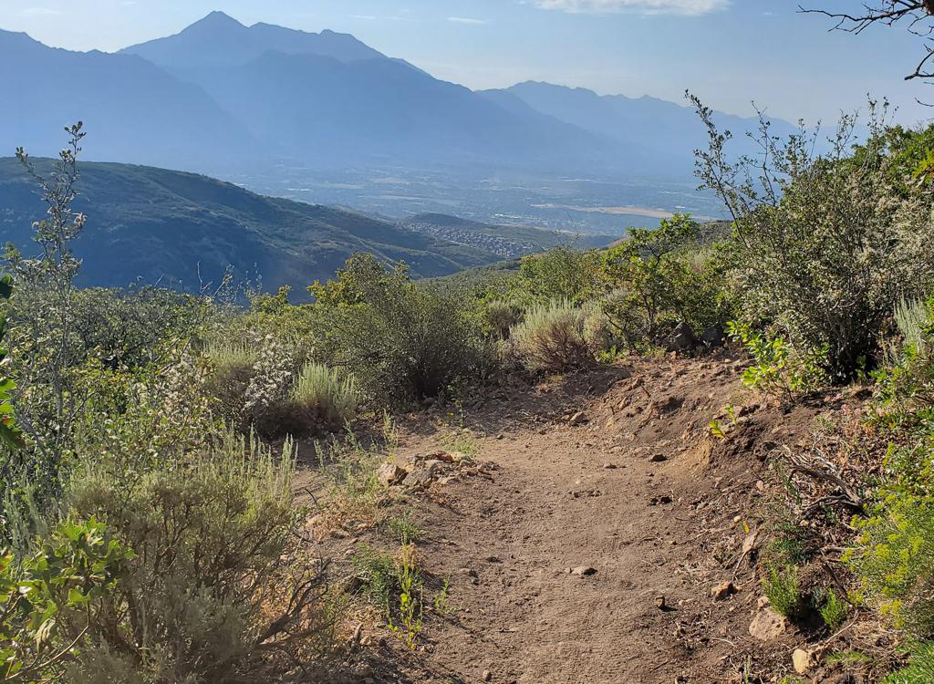
(3) A bit to the right and to the west is the continuing BST. That's your way down to the multi-trail intersection area at the bottom of the valley.

Gasline Trail. Thats not the one youre looking for. But it seems every time Im o...
Gasline Trail. That's not the one you're looking for. But it seems every time I'm on Ghost Falls, I run into a lost soul who took this trail thinking it was the BST.
Looking east uphill on the BST.
Now you'll drop steadily through brush and occasional oak scrub as the route carves out a big S shape to the bottom of Corner Canyon. At mile 0.9 from the Corner Canyon Road, the trail turns sharply right in a box elder grove and crosses a bridge over the creek.

From the bridge, your goal is to keep the bike aiming straight. You're pedaling west. On your right is a connector to the Corner Canyon trail. If you fork onto Corner Canyon, it's a mile down to Highland Drive, with a connector to the Creekside trail about 0.1 mile downhill.

As you enter the open area, the doubletrack to the left climbs uphill for connections to Canyon Hollow and Ghost Falls The big DT on the right descends Corner Canyon Keep heading straight west and uphill. Keep straight as Creekview crosses the BST 0.2 miles from the bridge. (Creekview heads north along the hillside for about a mile before dropping down to the creek and joining Corner Canyon to pass under Highland Drive.)

Follow the trail into the trees. In 2016, there's an unmarked split in the trail here, which rejoins about 50 feet later. Now you reach a marked trail fork. Keep right. The trail to your left, heading east and slightly uphill, is Canyon Hollow , destined for the top of Traverse Ridge.

Heres the bridge, as seen from the west side (the ride-uphill eastbound directio...
Here's the bridge, as seen from the west side (the ride-uphill eastbound direction).
Climbing up the Clarks Connector section of the BST. (Since this photo 10 years ...
Climbing up the Clark's Connector section of the BST. (Since this photo 10 years ago, there are water channels and exposed roots. So it's not quite this baby-smooth.)
About 50 feet further west is a second trail intersection. The right fork goes to the Coyote Hollow trailhead, just 100 feet away. This is officially the end of the Corner Canyon segment of the BST. (The continuing westbound BST is the Draper segment.

Fork left uphill and begin a semi-stiff climb on a trail that winds through thick oak forest. This is the combined Bonneville Shoreline Trail and Clark's Connector. After 1/10th mile of uphill climbing, you'll come to a T intersection. Clark's Trail is across the bridge to your left. Clark's is a one-way uphill-only route to the top of Traverse Ridge. Turn right to continue the BST.

So... turning it around... 
If you're westbound from the Traverse Mountain (Draper) section of the BST, here's your navigation:

90 degrees left just before the bridge of Clark's
0.1 later, keep R (L = Coyote TH)
50 feet, keep L (R = Canyon Hollow)
Descend broad trail, keeping straight east-northeast
Cross the DT intersection, keep straight until you see the bridge
Climb the ST, with a little piece of DT in the middle.

Little Rocky rests on the Clarks/BST sign at the T intersection (aiming towards ...
Little Rocky rests on the Clark's/BST sign at the T intersection (aiming towards Clark's).
Climbing westbound to get above those ridiculous monster homes.
We will now consider the stretch from Coyote Hollow to Potato Hill. Note that this is NOT officially part of the "Corner Canyon BST" and may be subject to closure under damp conditions. I discuss it here because the Coyoto-to-Potato bit is commonly used as part of a winter fat-bike loop ride ( Potato Hill , BST, Canyon Hollow , and east Ann's ).

From the Clark's intersection, the BST begins a modest but steady climb as it contours a small canyon to the west. It needs to gain altitude to get above the obscenely-sized mansions on the hillside above the temple.

Shortly after passing above the homes, 0.6 miles from Clark's, you'll reach the Potato Hill trail fork. The BST continues on the right. The Potato Hill trail will deliver you to Ann's Trail after 0.5 miles of gentle climbing, and in another 0.2 miles, to the Potato Trailhead on Traverse Mountain Road.

For trail connections further west, see the Draper BST page .

Alex approaches the Potato Hill fork from the Draper BST (were looking west). Po...
Alex approaches the Potato Hill fork from the Draper BST (we're looking west). Potato Hill is up and to the left.
 map
BST area map for Corner Canyon
Bonneville Shoreline TH on Corner Canyon Road:  From Draper, take 123rd South to 13th East and turn south (right). At the roundabout just down the hill, turn east (the equivalent of a left turn at the roundabout) on Pioneer Road. Go around one mile to 20th East, then turn right going south on Highland Drive. Turn left to the parking lot of Orson Smith Park, but immediately turn right as you enter the parking area. Drive on the gravel Corner Canyon Road 1.1 miles uphill. Turn right into the BST trailhead. Then northbound BST is on the uphill side of the road, across from the trailhead parking entry.
Coyote Hollow trailhead: From Traverse Ridge Road, turn to Mike Weir Drive. Drive about a mile until the road veers left downhill. Take the next right turn, turn right again, then left. You should now be on Gray Fox Drive. Take the next right into Coyote Hollow Court. The parking is on the right at the end of the pavement. After entering singletrack, the trail fork in 100 feet is the BST. Fork right to go westbound, or keep left to go east and north.
Corner Canyon (Equestrian Center) Trailhead:  On Highland Blvd. Climb the Corner Canyon singletrack, joining doubletrack on the way, to a wide intersection of multiple trails. The BST is across the wooden bridge 90 degrees to your left. You'll climb past connections to other trails, then just past Rattler, you'll reach the Corner Canyon Road trailhead.
Potato Hill: Take the Bluffdale exit from I-15 and turn east towards the mountains on Highland Drive. At the light at the top of the hill, turn right on Traverse Mountain Road. After one mile, pass Mike Weir Drive on your left. Look for the Potato Hill TH on your left about mile 1.3 from the light.
Red Rock (Mike Weir) trailhead: Leave I-15 and turn right at the light on Traverse Mountain Road. After one mile, turn left onto Mike Weir Drive. The trailhead parking is on your right, 1/2 mile later. A short connector takes you up to the BST.
Riding resources:
GPS track file (right-click and select "Save Target as..."):
     Corner Canyon BST from CC Road to Clarks
     BST CC Road to Sandy
     BST Clarks to west end
     Multi-track Draper Area file
Go to Draper Area Trails overview page
Map in new window for printing:   View
Lodging, camping, shops:    Links to southern SLC resources
Last updated 2016