

Looking north from the rim on the Windmill Loop. Original review and photos July 11, 2001 by Bruce Argyle, with latest update 2017.
Windmill Trail on Gooseberry Mesa
Includes Bowls and Ledges loop
Includes Bowls and Ledges loop
Gooseberry Mesa has a lot of awesome riding. The Windmill Trail runs from the Windmill Trailhead out to the cliffs, then west down to the North Rim Trail. Windmill itself is only 1.6 miles, but connects to other trails to yield satisfying amounts of riding. Most of the trail is intermediate technical, with a few challenges thrown in.
The trail is an intermediate aerobic because there's almost no altitude gain. On the slickrock
sections, you'll need quick power for ledges and bowls, but there are
no prolonged grunt climbs.

A cap-rock of hard Shinarump conglomerate of the Chinle Formation resists erosion, letting the softer layers below erode steeply. In the distance, you can see the skirts of Moenkopi Formation clays.

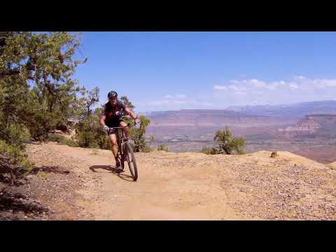
Bruce launches the lip of a rock hump. The cliff is 15 feet behind the camera.
There are some very close cliff exposures, so you might want to reconsider before taking your stupid
dog, reckless teenager, or clumsy neighbor on the Windmill Trail. It can
be managed by early-intermediates,
but riders need good bike-handling skills and the common sense not to
push beyond their ability
level while on the edge of a cliff.
Windmill Loop

The doubletrack skirts the windmill, then heads west through sage, juniper and pinion pine.
The Windmill Loop is a short quick sampler of the mesa's types of terrain. There's sage cruising
on double-track, technical slickrock, undulating technical singletrack,
and a cliffside cruise.
It can be connected to the Bowls and Ledges loop for a longer ride.
The Windmill Loop starts at the Windmill Trailhead (GPS N 37° 09.090' W 113° 09.973', altitude
5140 ft). From the windmill, you ride west on doubletrack. Stay on the
main dirt road, which
is usually the straight-ahead option -- there will be several side-roads.
At 0.9 miles, the
track forks. Keep right as you turn toward the north.

Almost to the rim on the doubletrack.

We've just reached the rim and have turned to the east.
When you arrive at the edge of the cliffs at mile 1.1 from the trailhead, turn hard to your
right and find the paint spots on the sandstone near the edge. You should
now be heading east.
Now simply follow the trail east along the north edge of the mesa. It's a quick ride. Most
of the riding is fairly flat, but there are a few short downhill spots.
After just over a mile on the singletrack, you'll reach a trail fork marked by a carsonite post. The trail that continues straight east goes to a viewpoint, then to the Yurt area. It will connect to The Gander on Gooseberry's northeast rim.

The trail snakes through the junipers near the cliff edge, sometimes coming as close as two or three feet.

There are smooth areas of fun cruising.
Turn to the right and head south 0.4 miles to the Windmill. The entire loop is just 2.4 miles.
It can be done (assuming you don't get lost) in around 1/2 hour, so it
makes a good "just got
here" late-afternoon ride for those who are staying on the mesa.
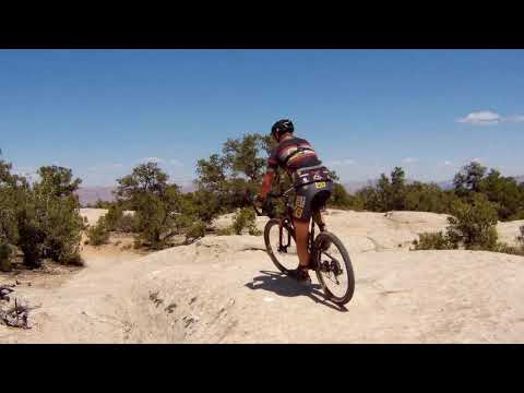
Bowls and Ledges

Typical riding surface for Gooseberry Mesa is white sandstone undulations, with patches of broken rock and hard-pack dirt between.
At the western end of the Windmill Trail, it hits the junction of the North Rim Trail and the
Bowls and Ledges Trail. Looping around Bowls and Ledges yields a nice
lariat-shaped ride of
4.7 miles.
Navigation of the Bowls and Ledges loop can seem more like a maze. The Slickrock 101 alternate
trails merge and branch off. There are connectors to the road and to North
Rim. And the few
carsonite trail-posts aren't particularly helpful in pinpointing your
location and destination.

Handlebar view on the Windmill Trail in 2001. This particular spot has been bypassed in favor of a safer line away from the cliff.

Bruce navigates a smoother section of Bowls and Ledges.
Let me simplify the navigation for you. Once you reach the carsonite sign that says "North
Rim," decide which direction you want to ride the loop -- clockwise or
counterclockwise. Take
that fork. Which way did you turn? You'll now fork the OPPOSITE direction
at EVERY trail fork
until you return to the sign.
OK, say you turned left (as I do in the Bowls and Ledges trail video). Now, fork to the right
at every trail fork. Right at Slickrock 101. Right at the White Trail
connector. Right at the
North Rim. And the next fork you'll come to is where you entered the loop.
Go left to exit.

"Bowls." Dropping to the bottom of a large bowl.

"Ledges." Entering a sharp dip by rolling off the ledge.
If you want to test the other trails in the area, I've provided GPS waypoints for you. By matching
the waypoint to the trail fork and consulting the map, you can know where
you are.
From the spot where Windmill hits North Rim (N37 08.812 W113 11.008), it's 0.6 miles clockwise
to Slickrock 101 (N37 08.662 W113 10.633). You'll note another fork to
your left, which is
the split between the easy and tech routes heading east.
Go to your right on the broad slickrock and climb gently west.
")
Arriving at Slickrock 101. (Camera facing north.)

Heading west on open rock.
The next trail fork comes after another 0.6 miles. At this fork (N37 08.508 W113 11.078), you'll
again fork to the right. (The left fork goes 100 yards to the mesa road
-- the White Trail.
So if you wind up on the mesa road, you blew past the trail fork without
seeing it.)
In 0.3 miles, you'll encounter the next fork. (This fork at N37 08.553 W113 11.251 can be subtle,
and is a common cause of lost bikers.) The left fork is the westbound
North Rim trail. You
want the eastbound North Rim, so you'll fork to the right.

Reaching the top of a steep ledge.

The north side of the Bowls and Ledges loop -- the North Rim trail -- is significantly more technical than the Windmill Trail.

There will be some steep ups and tricky downs, but it's all rideable for an experienced upper-intermediate.

Heading east on the North Rim trail, almost back to the Windmill Trail.
It's another 0.6 miles now to go east and return to the original fork where you entered the
loop. Keep straight (left) to return via the Windmill Trail. Or, go right
to repeat the loop
or reach one of the trails that forked off the loop.
Getting there -- North: As you approach Zion National
Park in Rockville, turn south (right) on Bridge Road. After crossing the Virgin River, the
dirt road winds up the mesa. Keep left at the fork at 1.5 miles. Continue to a total of
6.2 miles, where you turn right at a sign "Gooseberry Mesa." Another 3.6 miles
after the turnoff, take the right fork as you pass the outhouse. One mile
later, you'll see a windmill on the left side of the road. Turn into the
parking area at the windmill GPS N 37° 09.090' W 113° 09.973'.
Getting there -- South: As you pass through Hurricane heading east, turn right at the Highway 9 sign. (If you start exit town without making a right-turn, you went past it.) One block later, turn left and drive out of town. About 15 minutes later, you'll pass a gas station on the left-hand side, then some fields. Watch for a "Scenic Byway" sign, and turn left onto a dirt road. Two miles later, just as you reach the mountain, the Gooseberry Mesa road turns off on your left. Another 3.6 miles after the turnoff, take the right fork as you pass the outhouse. One mile later, you'll see a windmill on the left side of the road. Turn into the parking area at the windmill GPS N 37° 09.090' W 113° 09.973'.
Getting there -- South: As you pass through Hurricane heading east, turn right at the Highway 9 sign. (If you start exit town without making a right-turn, you went past it.) One block later, turn left and drive out of town. About 15 minutes later, you'll pass a gas station on the left-hand side, then some fields. Watch for a "Scenic Byway" sign, and turn left onto a dirt road. Two miles later, just as you reach the mountain, the Gooseberry Mesa road turns off on your left. Another 3.6 miles after the turnoff, take the right fork as you pass the outhouse. One mile later, you'll see a windmill on the left side of the road. Turn into the parking area at the windmill GPS N 37° 09.090' W 113° 09.973'.

The Windmill!

GPS track files and waypoints (right-click and "Save as..."):
"The Works" includes "Harris Secret Trail"and South Rim / North Rim trails: GPX
Tracks for Windmill, Bowls & Ledges area only: GPX
High-res topo for printing: View
Lodging, camping, shops: Links to St. George area resources
"The Works" includes "Harris Secret Trail"and South Rim / North Rim trails: GPX
Tracks for Windmill, Bowls & Ledges area only: GPX
High-res topo for printing: View
Lodging, camping, shops: Links to St. George area resources


