In the hoodoo area at the top, we're seeing seven mini-arches. Photos from March 8 and 9, 2017 with ride description by Bruce.
Sand Mountain
West Rim Trail, "The Maze," and Hurricane DunesSand Mountain lies just south of Sand Hollow Reservoir near Hurricane. It's not a casual ride,
and is best reserved for strong adventurous bikers who've already done the usual stuff in the
area. There's sand, rough rock, and a sustained tough climb. I recommend a fat bike for this
ride. Because, sand.
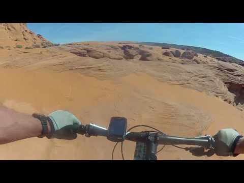
The ride offers great views and lots of Navajo sandstone slickrock. Much of the West Rim climb
is open rock (see the video), and at the top there are a couple of miles
of competing paths
through the hoodoos. If you want to use a standard mountain bike, expect
to hike for about
1/2 mile of your climb.

Bruce heads up the first slickrock area on the West Rim trail.

Rolling over the dunes on a Rocky Mountain Blizzard. Ride the virgin sand, not the stuff that's torn up by ATVs.
There's a reason why locals refer to this adventure as the "Hurricane
Dunes." Lots of sand. You'll fight through a long sandy stretch on
the doubletrack going up to the slickrock. And at the top, a few square
miles of sand dunes await.
So, again, FAT BIKE.
I'll discuss two riding options for Sand Mountain. One is an up-and-back along the west rim
of the mountain. This is my recommended ride. The round trip is about
17 miles, but will vary
depending on how much exploring you do in the hoodoos. The total climbing
will be around 2100
vertical feet. When you reach the dunes, play around and test your sand
skills. But go back
down the West Rim the way you came.J

ust getting started, about 1.5 miles into the ride. After another 4 miles, we'll be among the bumpy red sandstone at the top of the mountain on the skyline.

Fault Line trail, on the way back around two miles from the trailhead. It's the "long way round" but it's easy pedaling.
The second ride option is a loop that returns through the deep sand on the north side of the
mountain. Although it's about the same distance, it takes more time and
effort. And you're
more likely to get lost. You'll need to climb north to the top of the
dune area then find your
way to the main ATV path before deviating onto the Sand Dune Road to close
the loop. Route-finding
is difficult. The sand here is deeper and trickier than anything you encountered
on the way
up.
Note 1: In 2019, a new access route has been bulldozed just
downhill from where the West Rim trail forks away from the sand dunes
access ATV route (mile 2.5 of my track below). Follow the general ride
plan and you'll find your way.
Note 2: Sand dunes move with time. If you enter the sand dune area at the
top while following my GPS track, you may or may not find it a ride-able
route.
It's tough riding.
But if you want to check "fought through miles of deep sand to
conquer Sand Mountain" off your bucket list, you can follow my full
loop track.

Yeah, sand. That's my 4.8 fat tire's treadmark.

View to the north near the Sand Dune - West Rim trail intersection.
So, I didn't talk you out of it? Then let's ride.Start the ride in Warner Draw, west of Sand Mountain. The
trailhead is alongside the Highway 7 Southern Parkway. Take the Long
Valley exit (15) from SR-7 and turn north. At the T intersection, go right
on Washington Dam Road. After just less than a mile, Warner Draw Road
turns to the right and goes under SR-7. Find a spot to park, then start
your ride by crossing the cattle guard heading south.
Immediately after crossing the cattle guard, turn to the right (west). There will be ATV tracks
everywhere, and they may disguise the "official" route, shown as Pecan
Road on Google Maps.
Stay as close to the fence as you can until the route turns south in a
shallow washbottom.
In 2017 there was a carsonite post marking the trail.

Climbing the West Rim, wandering around on a broad slickrock area. This is Navajo sandstone.

Higher up, the trail alternates between this rough rock and sandy dirt.
The ATV path will meander south for a mile. Watch for a path climbing up out of the wash at
mile 1.3 from the trailhead. There was a marker here, but it wasn't easy
to notice. The path
will turn eastbound and begin climbing over the dry mud. ATV paths will
join. The trail is
occasionally bumpy and torn up by the gasoline crowd. But I had no "company"
on this trail
or on the West Rim -- in two days of riding -- as the motorheads were
all riding to the dunes
from the Sand Hollow Reservoir staging area.
After 0.2 miles from leaving the wash road, Watch for a carsonite trail marker and fork 90
degrees left on the Fault Line trail. You're now going northeast (exactly
the opposite direction
from the washbottom) on clay ATV track in a little valley. To your left
is a reef of Shinarump
conglomerate. When you reach a trail fork at mile 2.1, veer to the right
and uphill on the
Sand Dune road. (Note: you can reach this spot in just 0.7 miles by climbing
the Razorback
ATV route to Fault Line. The path is shown on my map, and is the return
path of my GPS track.
But it's a brutally steep shortcut and I don't like to start my rides
that way.)

Looking back at the Pine Valley Mountains as we pass through some hoodoos.

The bike is a Rocky Mountain Blizzard -50 fat bike with a Bluto shock and Bud/Lou tire combination. It's still loaded with winter survival gear.
The ATV route stays hard-pack dirt to mile 2.3. Then you hit the sand. There's just over 1/4
mile of deep sand, very ride-able on my Rocky Mountain -50 with 4.8-inch
tires. Riders on XC
bikes will hike this stretch. The trail flattens and becomes more firm
as you approach the
West Rim fork at mile 2.7 from the trailhead. My impression was that the
rest of the trail
could be done on generously-sized cross-country tires, but it would depend
on the season and
ATV traffic.
Very quickly after turning onto West Rim, you'll hit slickrock. The ATV path appears as a darkened
or shiny area. But go where you want, while remembering that you're going
straight up the hill
along the west rim of the mountain. I found that meandering back and forth
was a great (and
fun) leg-saver when compared to the previous day's straight-up attack
along the ATV path. You
may note some old white spots marking a side route. Play if you want.

Peeking through the window, there's a bit of Washington visible in the distance.

This is the spot where the trails split up and meander through the hoodoos. Allow extra time for route-finding.
Keep to the right at any intersections. You'll now be constrained to a defined path, which
will alternate between semi-rough rock and soft dirt. Pass through a first
set of hoodoos and
keep climbing.
As you reach a high spot at mile 4.9, you'll see hoodoos ahead to your left, with the mountain
dropping away on your right. Suddenly there are multiple possible paths.
I went through this
area three times and couldn't stay on the same route. So my GPS track
follows one of a few
possible routes. Work to the southeast, until you're just below the ATV-track
scar on the sage-covered
hill (but still in the slickrock area). Then find a pathway that leads
to a steep drop, and
below you is an open area, then a slot between two big sandstone hoodoos.
That slot is your
continuing path.

View to the south into Arizona as the trail skirts the cliff edge.

Sometimes there's a definite trail. Other times, you just feel your way southeast.
At mile 7.0 or so, the shape of the mountain forces you up out of the hoodoos to join an ATV
track. (It's the continuation of the ATV track you saw on the mountain
where the routes started
splitting.) After about 100 feet, drop to the right back onto the sandstone.
The ATV track,
meantime, will climb up to the top of the mountain to enter the dunes
at their highest point.
Keep working to the southeast, going around in circles and blundering into dead-ends regularly.
My GPS track "looks" really clean, but that's after deleting a LOT of
"side trips."
Around mile 8.5, the path becomes harder to follow. Find a spot to watch the gasoline addicts
play, have lunch, then turn around and head back the way you came.
If you're determined for some sand-action, keep uphill and blunder your way toward the dunes.
If you hit the dunes on the south side, you can gain speed on exposed
rock before hitting the
piles of soft stuff. Untracked dune holds up under your tires better,
so don't follow the four-wheelers'
paths.

Lunch break.

On the edge of the dune area, looking northeast. For size persective, those specks just below and left of center are ATVs.
So, you're doing the loop ride? I did both out-and-back and loop versions, so believe me when
I tell you out-and-back is more fun. But here we go.
Find a route to the tip-top of the dune area. I went to the far eastern side, where I found
the climbing easier. Once on the ridgeline of the uppermost dune, veer
to the left to head
northwest on top of the dune. About 2/3 of a sand mile later (one sand
mile = 10 dirt miles
= 20 road miles), find the main path where ATVs are entering the area
and descend north-ish
down a draw full of deep soft sand. It's downhill, yet you'll still be
working hard.
After a bit over a mile descending on the sandy access trail, you'll -- hopefully-- see a trail
sign. Head for it, and fork 90 degrees to the left. This is the Sand Dune
road that will take
you back to the West Rim. (It's easy to "not see" the trail, because 99%
of the ATV traffic
follows the main path descending toward the ATV reservoir staging area.)

Critical fork. This is where you pick up the return path. We're looking west.

Dropping into a ravine as we head northwest toward the Pine Valley Mountains. Still a lot of vertical to go.
Follow what seems to be the main path, staying straight when in doubt. Two notes: (1) At around
mile 13, the trail splits. I went straight down the wash. It appears that
forking right would
take you down the ridge to rejoin later. (2) When you reach a huge dune,
the route drops off
to the left. Yes, straight down the impossibly-steep face of the dune
into the ravine. Once
you reach the bottom, keep straight to climb up the other side.
Back at the Dune Road - West Rim fork, keep straight. When you reach the fork to Fault Line,
keep left to retrace your outgoing path. For a shortcut that shaves off
1.5 miles, but has
some steep spots, follow my GPS track by turning right. After 1/3 mile,
turn 90 degrees left
downhill on Razorback.
Bottom Line!The West Rim slickrock ride is high-voltage fun. Don't be put off by the fact that ATVs use
this area. They're nice folks and they won't be in your way. You DO, however,
have to get past
the sand on the climb. So I recommend a fat bike. Again, out-and-back
is my recommendation.
The loop ride through the sandy north slope is for show-offs and morons
like me who don't know
any better.

Sand is hard work, even with a fatty.
Riding notes, slickrock and dune loop:
0.0 Cross cattle guard, go right (west)
N37 06.743 W113 26.282
0.2 Southwest in wash bottom
N37 06.709 W113 26.453
1.3 Veer L out of wash (southeast)
N37 05.937 W113 27.037
1.5 Fork L (northeast), Fault Line trail
N37 05.816 W113 26.902
2.1 Keep R and uphill (east)
N37 06.232 W113 26.489
2.7 Fork R on West Rim
N37 06.321 W113 25.970
3.0 Keep R (L=to John's)
N37 06.125 W113 25.899
3.6 Keep R (John's rejoins)
N37 05.745 W113 26.149
3.7 Keep R (L=sandy DT to The Maze)
N37 05.671 W113 26.189
4.9 Slickrock and hoodoos, work southeast
N37 04.839 W113 26.534
5.6 Passage east to lower trail!
N37 04.490 W113 26.435
7.0 Rejoin upper DT, the leave to R
N37 03.827 W113 25.809
8.5 Turn-around for XC out-and-back
ride
For loop, east-southeast at
edge of dunes
9.2 R to go northeast climbing along edge of dunes
N37 03.140 W113 24.256
9.7 Top of dune area, work northwest
10.4 R downhill on main access path (north)
N37 03.797 W113 24.313
Lots of deep sand from here
down!
11.6 L on Dunes DT, critical fork!
N37 04.640 W113 23.734
(straight or R= down to
reservoir ATV staging)
13ish straight and descend wash (R=ridge alt)
14.6 Drop steep L off dune, up DT opposite side
N37 06.317 W113 25.636
15.0 West Rim fork, straight N37 06.321 W113 25.970
15.6 Fork R this time, go northeast on Fault Line
N37 06.247 W113 26.460
15.9 L downhill N37 06.469 W113 26.294
16.1 Veer R toward road
16.3 Back at parking

Map of Sand Mountain
Getting there:To get there from the south, take I-15's exit 2 to Highway 7, the Southern
Parkway. Go 15 miles to exit 15 for the Long Valley. Turn left under the
highway, then right on Washington Dam Road.
From Highway 9 just west of Hurricane, take the Sand Hollow Road south
until you pass Sand Hollow State Park, then turn right onto Highway 7. Go
west about three miles to exit 15 and turn right (north). At the stop
sign, go right on Washington Dam Road.
After 0.9 miles on Washington Dam Road, turn right at Warner Draw Road and
go under the highway. Immediately find a place to park. The ride starts by
heading south up the valley. To avoid the confusion of multiple changing
ATV routes, start by working to your right immediately after you cross the
cattle guard until you find the main road in the bottom of the wash.
Camping: Quail Creek State Park
Water: none
Bathrooms: none at trailhead