Rolling the sandstone heading west on a counterclockwise ride. Photos and trail ...
Rolling the sandstone heading west on a counterclockwise ride. Photos and trail review May 23, 2017 by Bruce.
Rodeo Trail

The Rodeo trail is a loop extending off the Chisholm trail near Horsethief Campground in the Horsethief mountain bike riding area . The trail was completed in May 2017. Rodeo is 8.7 miles long, but to ride the loop requires a bit of the Chisholm trail, making the minimum ride 9.2 miles.

Note June 13, 2017: Per Moab Trail Mix, until further notice, riders should do this trail clockwise. Note that my original ride (and video) were done in the opposite direction, before the trail was designated as one-way.

The trail is early-intermediate in technical requirement overall. The length makes it moderately strenuous, with 900 vertical feet of total climbing over the course of the loop.
The slickrock is generally well-weathered and flat, presenting few challenges. E...
The slickrock is generally well-weathered and flat, presenting few challenges. Eastbound on the southern limb.
Cruising along the edge of the rock heading west.
You'll need to ride the Chisholm Trail to reach Rodeo. The most direct access is from the West Horsethief trailhead on the campground road (see below). Only slightly longer is the route from the Highway 313 Chisholm trailhead. How far you ride on Chisholm depends on which direction you'll be riding the loop.
From the West Horsethief (Chisholm) trailhead...

Pedal south on Chisholm 0.1 miles, then fork hard right on the alternate Chisholm route to the campground. Go another 0.1 miles to the 4-way intersection of Chisholm with Rodeo and Rowdy. Turn left on Rodeo for a counterclockwise ride.

For a clockwise ride, go south as above, but keep straight at the 0.1-mile trail fork. Continue another 0.3 miles, then turn right on Rodeo just before Chisholm goes up and over a pipeline.

From West Horsethief, heading south 0.1 miles to the split in the Chisholm trail...
From West Horsethief, heading south 0.1 miles to the split in the Chisholm trail.
Northbound on Chisholm, approaching the spot where Chisholm splits (counterclock...
Northbound on Chisholm, approaching the spot where Chisholm splits (counterclockwise ride).
From the Highway 313 (Chisholm) trailhead...

Cross the road and pedal generally downhill on Chisholm for 0.5 miles. Just after crossing the pipeline, fork left on Rodeo for the clockwise ride.

For the counterclockwise ride, continue straight on Chisholm for another 0.3 miles. As you reach a trail sign, drop to the left on the slickrock. Then after 0.1 miles, fork left at the 4-way where Chisholm joins the Rowdy loop.

Whichever direction you choose to ride, the loop will be a reverse-profile ride. That is, you'll descend for half the ride, then climb back to the trailhead. So you'll work harder on the second half. Plan your time and water budget accordingly.
While most of the trees are juniper, there will be a few stands of pinion.
Westbound on the counterclockwise ride. Note the absense of stuff on the horizon...
Westbound on the counterclockwise ride. Note the absense of "stuff" on the horizon. Your "views" are just the features within 100 feet of your bicycle.
The trail alternates between short spans of slickrock and dirt singletrack. As you descend toward the west -- either direction -- the dirt sections become longer. And in 2017, the dirt becomes much softer. You will work a little.
The overall rate of descent is gentle. The trail go from around 5400 feet elevation down to 5150. But there will be little climbs and descents along the way, in both directions. So even through the absolute change is just over 250 feet, there will be around 900 vertical feet of total climbing during your ride.
Zipping around a corner as the trail skirts a small wash.
On the far west end of the loop, working our way south.
None of the slickrock presents a particular challenge to an intermediate rider. If you're looking for something extreme to challenge yourself, you've picked the wrong trail. Once the loose dirt is packed down, this will be a cruiser of a ride.
In May 2017, there was enough loose dirt to make the western three miles of the loop a bit of a grunt. And while I did bog down a couple of times, there were no long hikes caused by the trail's softness. A fat bike would fly right through.
Taking the drop into deep sand. Made it across!
Rolling up and over. Not too techy.
This isn't a "view ride." The trees and rocks are pretty, but there's little to see on the horizon. No cliffs, valleys, or majestic mountains. Just the stuff that's within 100 feet of your bike.
Bottom Line!
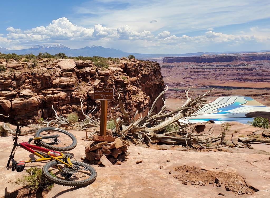
The ride itself is the "star of the show" here, as the area has no distant majestic scenes. It's good riding of satisfying length, and once the dirt sections pack down, it will be awesome.
Riding the cliff edge as the trail heads back north on the counterclockwise ride...
Riding the cliff edge as the trail heads back north on the counterclockwise ride.
Very nice job on the trail armor here!
Riding notes, counterclockwise from West Horsethief:
(NOTE 6/13/17: Until further notice riders should go CLOCKWISE per Moab Trail Mix. So do it opposite from these directions!)

0.0  South on Chisholm from trailhead
       N38 35.126 W109 48.438
0.1  Hard R on alternate Chisholm
       N38 35.035 W109 48.426
0.2  Fork L on Rodeo (straight or R = Rowdy)
       N38 35.014 W109 48.509
8.9  L on Chisholm N38 34.908 W109 48.249
9.1  Straight N38 35.035 W109 48.426
9.2  Back at parking
Rodeo loop trail
Rodeo loop trail
Getting there:
From I-70 and Crescent Junction, drive south on US-191 for 20 miles (about 9 miles north of the Colorado River if you're driving out from Moab) to Highway 313. Drive uphill 11 miles.
Horsethief Campground Road Trailhead:  Turn left on gravel road at the campground sign 11.8 miles from Highway 191. After 0.1 miles, turn left into the fenced parking area. Pedal south on Chisholm 0.1 miles, then fork hard right on the alternate Chisholm route to the campground. Go another 0.1 miles to the 4-way intersection of Chisholm with Rodeo and Rowdy. Turn left on Rodeo.
Highway 313 Horsethief Area (Chisholm) Trailhead:  At mile 12.5, spot the trailhead kiosk on the left side of the road. Turn into parking. Start the ride to the campground loops by taking the Chisholm singletrack westbound across the road. The southern limb of Rodeo meets Chisholm just after you cross the pipeline. To reach the northern side, go another 1/4 mile then keep left as the routes split. Descend to the 4-way intersection as above.

Riding resources:
GPS track files (right-click and select "Save Target as..."):
   GPX multi-track, area trails
   Rodeo trail only
   Loop ride from West Horsethief
Topo map for printing:   View Horsethief Area Trails topo
Lodging, camping, shops: Link to Moab area resources

Bathrooms: Horsethief Campground
Water: Horsethief Campground
Camping: Developed campground, nightly fee