View south toward Midway and Deer Creek from upper Happy Camper. Trail review by...
View south toward Midway and Deer Creek from upper Happy Camper. Trail review by Bruce on June 16, 2020.
Pine Canyon Bike Park
Area Trails including Birdie Shot

Pine Canyon above Midway is part of the Wasatch Mountain State Park. The state park includes popular rides such as WOW , Phosphate Loop , Dutch Hollow , and the Crows Nest loops . This page discusses the Pine Canyon Bike Park area trails and the Birdie Shot trail connecting lower WOW to Snake Creek Canyon behind the golf course.

The most popular feature in the bike park is the pump track. Families with young children are the primary users. If you're an expert rider determined to do gnarly stuff on the pump track, wait your turn and don't intimidate the youngsters.
Entry to the pump track (and the beginner flow trail) from Happy Camper.
Banked turn on the Pine Canyon Flow trail, an expert-level downhill.
The starting elevation is 5750 feet at the bottom of the Happy Camper trail. The expected riding season is late May through October. The lower Bike Park trails are suitable for kids and beginners. The Pine Canyon Flow expert trail has substantial jumps and should be done only by experts.
The area features rounded hills covered with gambel oak and maple. There are occasional meadows of sage and wildflowers. Rock outcrops are few, so the area trails are almost entirely dirt ribbon. Climbing is gentle and steady. On the other hand, there are engineered bumps on the downhill flow trails to add to the fun.
Heading uphill in Pine Canyon on Happy Camper, which is the key to all the lower...
Heading uphill in Pine Canyon on Happy Camper, which is the key to all the lower canyon trails.
Fee station at the bike park trailhead. Behind it is the return from the beginne...
Fee station at the bike park trailhead. Behind it is the return from the beginner flow trail, uphill is Happy Camper.
The Bike Park trailhead is on SR 222, just a mile uphill from the state park visitor's center. The improved gravel parking lot has room for around 12 cars, but it will be very crowded with riding families on weekends. Alternatively, you can park at the WOW trailhead one mile further up the road and take the singletrack down to the trails.

The state park is a fee area ($7 per car in 2020). You'll need to deposit your entry fee in the receiver and post the receipt on your dash before pedaling away from the trailhead.

Happy Camper trail

At its lower end, Happy Camper begins on the Pine Canyon Road just before it joins SR 222. It passes the bike park trailhead, the pump track, and the entry to the intermediate downhill flow trail. Happy Camper ends at a 4-way trail intersection of the WOW connector, Phosphate connector, and the entry to the expert Pine Canyon Flow trail.

Looking downhill on Happy Camper. The trail is suitable for beginning riders and...
Looking downhill on Happy Camper. The trail is suitable for beginning riders and children.
Looking uphill on Happy Camper. Were just a bit beyond the connector to the camp...
Looking uphill on Happy Camper. We're just a bit beyond the connector to the campground and the exit from the intermediate downhill flow trail.
Happy Camper is the key to reaching all the other area trails. The rate of climb and the surface conditions of the trail make it suitable for beginning riders. It's 1.2 miles in total length with 300 feet of elevation change.

The distance from the bike park trailhead to the intersection at the top the flow trail is 0.8 miles. The 0.4 miles below the parking area is used mostly by riders coming from town by bicycle. The section from Pine Canyon Road to just above the pump track has been hardened with gravel.

Pump Track

The pump track is 1/10th mile north (uphill) from the bike park trailhead. Go uphill from the parking lot (past the exit from the beginner Flow trail) to find a broad Happy Camper trail. Turn left uphill and pedal 450 feet. Drop to your left into the pump track area.

Looking northwest, just after entering the pump track going counterclockwise.
Looking northwest. The entry to the beginner flow trail is right at the left edg...
Looking northwest. The entry to the beginner flow trail is right at the left edge of this photo.
The pump track is fairly modest in size, consisting of an oval loop with a center shortcut. Most of the riders will be young children including preschool age. There are two shaded picnic tables for parental hanging-out.
Beginner Flow trail

At the south (down-canyon) side of the Pump Track oval, the beginner Flow trail heads back to the parking area. It's only 400 feet in length, with gentle rollers to improve balance on the bike.

Looking down the beginner flow trail. Mild bumps and low speed.
Entry to the intermediate downhill flow trail off Happy Camper.
Intermediate Downhill Flow trail

As you continue uphill on Happy Camper, you'll pass the exit from the expert Flow trail, then the Campground Connector (a short spur that goes to the road across from the campground entrance). Right next to the campground spur is the exit from the intermediate Flow trail. At mile 0.5 from the trailhead, you'll reach the top of the intermediate downhill Flow trail.

The Flow trail is 0.3 miles long with only 80 feet of elevation loss. Turns are banked and wide. There are some roller bumps, but none of them require that your tires leave the ground.

Beginners will have no problems here. But if you're taking little kids, be aware that high-speed riders may come flying down this trail. So I'd recommend having a rear-guard parent tailing behind.

View down the trail. Turns are easy and the bumps are simple to roll if youre no...
View down the trail. Turns are easy and the bumps are simple to roll if you're not a fan of "taking air" yet.
At the 4-way. To the left is the trail uphill to the Phosphate Loop. On the righ...
At the 4-way. To the left is the trail uphill to the Phosphate Loop. On the right is the drop-in to the flow trail.
Pine Canyon Flow Expert trail

This is the trail that brings riders to the Pine Canyon Bike Park. The entry to the trail is where Happy Camper reaches the Phosphate to WOW connector trail. As you reach the 4-way at mile 0.8 from the trailhead, keep right to enter the Flow trail. The straight and left uphill trail connects through switchbacks to the Phosphate Loop uphill. The 160 degree left turn is the connector trail to the WOW parking area.

The expert Flow trail is 0.5 miles long with 200 feet of elevation loss. It starts out fairly mild with highly-banked turns and low tabletops. The trail is designed to be taken with speed. As you continue downhill, the bumps get bigger. It becomes very difficult to keep wheels on the ground, so this is a true expert flow trail.
Looking south down the trail. In mid-photo are two bumps that can be done as a g...
Looking south down the trail. In mid-photo are two bumps that can be done as a gap jump.
A bigger double bump thats designed to be a gap jump. I found the rock launch a ...
A bigger double bump that's designed to be a gap jump. I found the rock launch a bit too "sendy" for my taste.
While some ride-arounds are appearing to the side of some of the jumps, it's not a good idea to ride this trail unless you're prepared to take air. Some of the features have a "lip" where you either have to launch way up, or slow to a crawl where you risk being hit from behind by the next rider.

The loop down and back up to the top is 1.2 miles, so doing multiple runs is not tough.

Birdie Shot trail

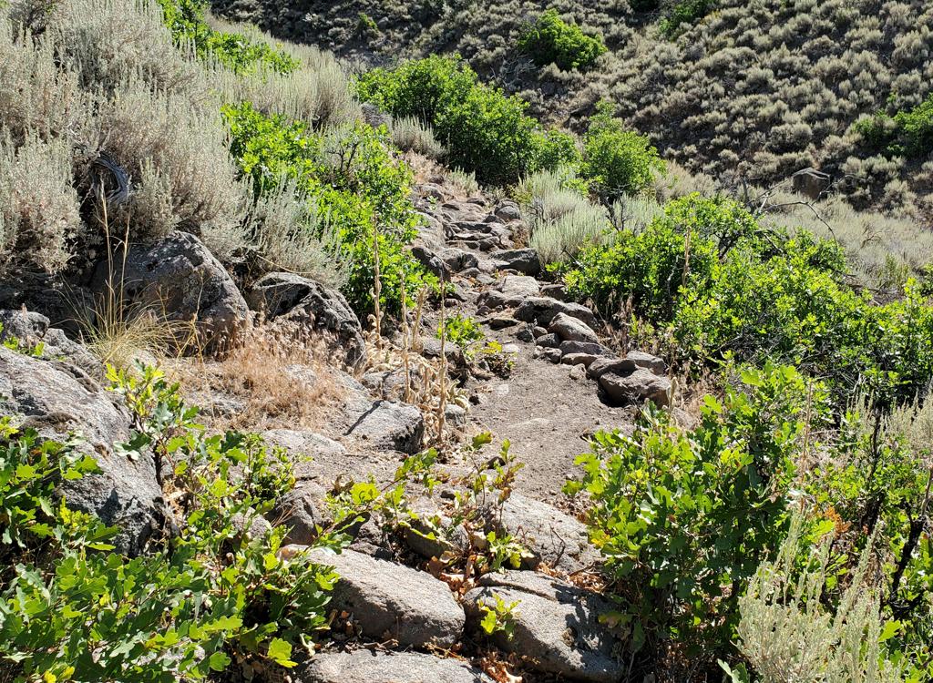
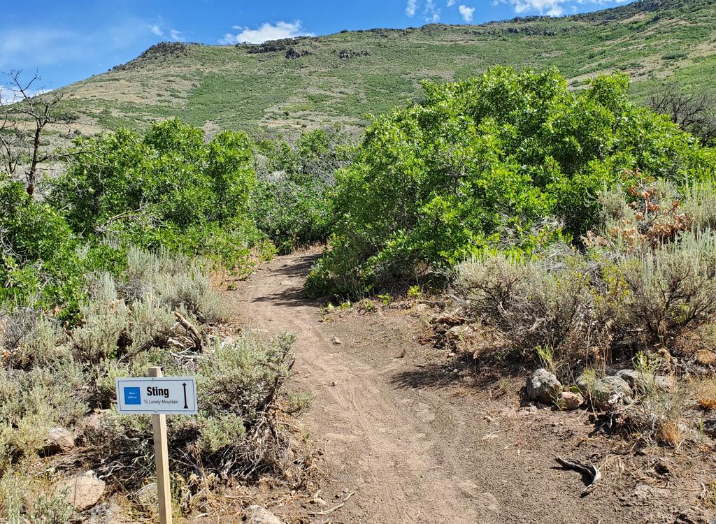
The Birdie Shot trail connects the back of the golf course in Snake Creek Canyon to the WOW trail. It's a two-way trail, although I expect that most riders will use it as a descending route. The trail is 1.4 miles long with a bit over 400 vertical feet of elevation change.

Looking west into Snake Canyon from Birdie Shot.
Looking uphill on WOW as we climb to Birdie Shot for the downhill. I like this d...
Looking uphill on WOW as we climb to Birdie Shot for the downhill. I like this direction because the climbing is easier on my old legs.
The upper end of Birdie Shot forks away from WOW on a ridgeline 1.2 miles and 150 vertical feet uphill from the WOW trailhead. If you're starting from the Bike Park trailhead it will be 2.7 miles with 450 feet of climbing to reach the ridgeline trail fork.
The upper mile of Birdie Shot drops through constant tight turns as it descends a dry oak and bitterbrush hillside. The turns don't allow for a lot of speed at this time because the new trail is still a bit loose and the riding lines on the berms haven't packed in.
Looking down into Snake Canyon at the entry into Birdie Shot from WOW.
View to the south as we descend.
There are nice views of Deer Creek, Cascade Mountain and Timpanogos to the southwest, and the mountains of the Wasatch Ridge above the Cottonwood Canyons in the northwest.
The lower half-mile of Birdie Shot is a winding series of turns on a grassy meadow. In 2020 it's all still a bit bumpy and loose, but I expect it will soon allow for more speed. When you reach a trail fork, turn right to descend further. The straight (left) fork heading east will join doubletrack connecting to the campground (see below).

If you're doing a loop (with Birdie Shot as your downhill), pedal west on gravel from the trail's end. In 100 yards, turn left, then left again on the Snake Canyon road. It will take you down to the Wasatch Mountain State Park visitor center.

Snaking around on the lower trail as we approach the golf course.
Coasting down the doubletrack toward the campground. Not going to recommend doin...
Coasting down the doubletrack toward the campground. Not going to recommend doing this bit of trail unless you're staying in the campground.
Campground Connector

At mile 1.0 from the top of Birdie Shot, 0.4 miles from the bottom, the campground connector forks off on the left. After 100 yards of new singletrack it joins an old doubletrack road-cut as it descends to the east. It will cross a campground nature trail at mile 0.3, then hit the back of a paved camping loop at 0.5. To exit the campground and reconnect to Happy Camper, just keep heading east, then turn right downhill on the road that connects the two campgrounds and follow it to the main entrance.

Map of the bike park area
Getting there, Pine Canyon Bike Park trailhead:  From Provo Canyon, drive east to the end of Deer Creek Reservoir. Right where the water ends, turn left (north) on U-113. Zero your odometer. Drive north 3.8 miles into Midway. On Main Street, turn left (west) onto Highway 222. Follow the signs for Wasatch Mountain State Park and/or for Guardsman Pass, staying on 222.  Pine Canyon Road will join on your right. Just after you pass the golf course entry (on your left), watch for the bike park trailhead on your right.

FEE:  In 2021, $10 per car ($5 seniors). Self-service fee deposit stations are located throughout the canyon, including the Bike Park trailhead, the WOW trailheads, and the campground. Bring exact cash or a checkbook. Plus, minor detail, a pencil or pen to fill out the fee envelope and dashboard ticket.

Camping:  State park.
Bathrooms:  WOW trailheads, campground
Water:  campground

From Salt Lake City, go up Parleys Canyon on I-80, then turn right (south) on US-40. Drive all the way into the middle of Heber, then at 100 South turn right on SR 113 to Midway. In Midway, continue straight as SR 113 turns south, and you'll be on SR 222. Go 2 blocks  to 200 East and turn right. Turn left at 200 North and go about 1/2 mile west and SR 222 will turn right to be northbound again. When the road turns west, turn right to stay east of the golf course on 222. Once you pass the campground, look for the parking area on the right about 1/4 mile uphill.
Birdie Shot trailhead:  On SR 222, as you come to the intersection at the main state park building, keep straight. You'll be on Snake Creek Drive. Go 1.0 mile to the uphill end of the golf course and turn right on gravel road. Turn right again after 100 yards and go 1/10th mile to a small parking circle. There is no fee station at Birdie Shot at this time (June 2020), so you'll need to pay your day-use fee elsewhere and place the receipt on your dash before parking here.
Campground/Day-use trailhead:  Just after SR 222 and the Pine Canyon Road join at the mouth of the canyon, drive uphill past the golf course entry. When you reach the campground entry (on the left), turn and go through the entry station (paying the day-use fee rather than the camping fee), then go to the right for the day-user parking lot. On your bike, exit the campground back to SR 222 and cross the road to the singletrack. A left turn uphill on Happy Camper takes you to the top of the intermediate or expert flow trails. Staying right downhill will take you to the pump track and beginner flow trail.
Riding resources:
See also:  WOW trail page , Phosphate , Dutch Hollow , Crows Nest GPS track files (right-click and "Save as..."):
   Pine Canyon GPX multi-track area file
   Tracks including Dutch Hollow
High-res aerial map for printing:  View
Lodging, camping, shops: Links to area resources