View west toward the Pine Valley Mountains. Photos and ride description December...
View west toward the Pine Valley Mountains. Photos and ride description December 8, 2010.
Nephi's Twist

The official Nephi's Twist trail is a doubletrack heading up a wash from La Verkin Creek to the Moenkopi Trail. It's about 1.5 miles long, and has a ridiculously steep section near the upper end. If you're doing the official ride, I'd suggest downhill only, or do it as an out-and-back from the bottom doing only the first 0.8 mile.

The Nephi's Twist singletrack is an experts-only romp along a ridgeline of Moenkopi clay. It starts on a spur off the Moenkopi Trail and connects to Nephi's Twist DT about 0.7 miles uphill from the bottom trailhead. The fun stuff is 3/4 mile in length. The ride can be done as a 3-mile DH with shuttle (or with a 3-mile road return), or as a 2-mile loop (which would include a stiff climb vs push-a-bike).
View south as we head down Nephis Twist singletrack.
View south as we head down Nephi's Twist singletrack.
Heading around the south side of the little knoll, weve found the trail.
Heading around the south side of the little knoll, we've found the trail.
OK, here's Qualifier Number 1: I believe the singletrack is an "unauthorized" trail. Both ends are certainly well-hidden. You'll need to follow the directions carefully, ideally using a GPS navigator, to find it. And understand that, if the BLM requests that the singletrack trail information be removed, it will disappear quickly.

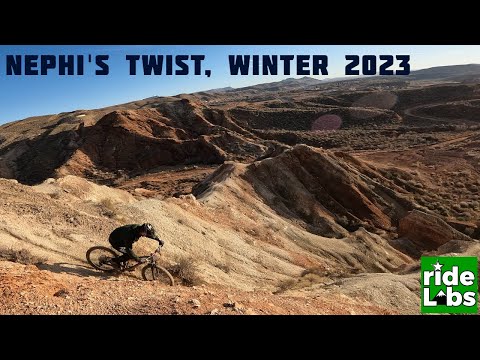
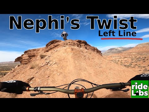
Qualifier Number 2: This trail is for REAL experts only. Seriously. And if heights make you nervous, you have no business on this trail. The path sits on a fin of Moenkopi shale, breaking away quickly on each side with cliff-like steepness.

Nephi's Twist Right Line

[Back to video list ]
First, get to the top of the hill, either by riding the DT from the bottom trailhead, or parking at the upper (Moenkopi) trailhead.

From the shooting range sign (about 150 yards from SR-9), head north on the doubletrack. As you dip through a tiny wash, a DT forks left. Keep right. After 1/10 mile, keep right at another fork. (These two left forks join after 1/10 mile and plunge down to the Nephi's Twist doubletrack trailhead. You'll be on that DT once you've ridden the ridge.)

At mile 0.4, fork left off the Moenkopi trail. Angle gently uphill on the DT heading west. As the trail comes over a rise and turns a little to the right, look for singletrack on your left. (The singletrack was hidden in the brush, totally invisible.) This ST will head south to circle around the south side of the small knoll.
Weve dropped off the knoll and entered the zone of Moenkopi clay and mudstone. T...
We've dropped off the knoll and entered the zone of Moenkopi clay and mudstone. The banded ridges contain gypsum crystal.
The trail is now getting serious. The sharp ridgelines are about to get spooky. ...
The trail is now getting serious. The sharp ridgelines are about to get spooky. We're heading south.
The trail will now descend to the west. Once you hit the red dirt, it will veer southwest, then finally south.

The narrowest parts of the ridgeline are spooky-thin. Not enough room to walk alongside a bike. There's a good chance that, if you stop and put a foot down, the foot will land on air and you'll tumble.

Nephi's Twist with the Left Line and BIG jump at the end

[Back to video list ]
After the trail turns south, stay on the ridgetop. Two routes will plunge off the ridge heading west -- to your right. (These connect to highly technical alternate rides.) The ridgeline will descend south into the bottom of a wash. Follow the wash out to doubletrack.

When you hit the doubletrack, you can turn left and head uphill for another loop. There's a very steep section of 15% grade for 0.1 mile. For most of us, this will be a push-a-bike.

Almost to the bottom. Well drop into the wash at upper right.
Almost to the bottom. We'll drop into the wash at upper right.
On Nephis Twist, were heading west back toward the bottom.
On Nephi's Twist, we're heading west back toward the bottom.
For the shuttled ride or a road return, turn left (west) and descend. Just stay in the bottom of the wash. When you hit the bottom at La Verkin Creek, turn left and follow the paved roads south to SR-17. After a mile on SR-17, turn left (east) on SR-9. You'll do about 600 vertical on the climb up SR-9 back to the trailhead.
Riding notes, ST from the top:
0.0   From the shooting range sign, head north on DT
      Immediately keep R N37 13.683 W113 15.188
        (L=DT to bottom)
0.2   Keep R N37 13.793 W113 15.212 (L=alternate to downhill DT)
0.4   Fork L off Moenkopi on DT N37 13.950 W113 15.222
0.7   At high point of DT, find trail on left N37 14.048 W113 15.495
        (Trail will wrap around to the south side of the small knoll)
1.1   South (L) on ridge N37 13.955 W113 15.770
       (Option: steep plunge R to alternates
       split at N37 13.938 W113 15.806)
1.2   Option L on ridge vs R down then L N37 13.897 W113 15.751
        (Or R uphill toward alternates)
1.3   In wash bottom heading south N37 13.857 W113 15.791
1.4   At DT, R downhill N37 13.766 W113 15.894
        (Option L uphill for loop, or to return to upper TH)
2.0   Fork L N37 13.799 W113 15.380
2.1   L for another loop N37 13.793 W113 15.212
        R to return to car  at shooting range
1.5   Keep R downhill N37 13.753 W113 15.956 (L=to water tank)
1.7   Keep R downhill N37 13.744 W113 16.139 
        (L= to subdivision roads)
2.1   At bottom TH N37 13.893 W113 16.428, turn L
        Stay L on paved roads until you reach SR-17 at 2.9
3.9   Traffic light, L on SR-9
5.7    L into parking area
5.8    Back at car
There are two alternate routes that fork off about a mile into the ride (keep left to stay on the main trail). Both of these alternates require that you pack your bike up a steep slope to get on top again. Both are highly technical; extreme to the point of potentially deadly. You'll encounter ribbons of trail on top of knife-blade ridges, with the slope breaking away so quickly that there's no place to put a foot down. On these ridges, there will be sudden plunges and steep climbs. There is no Stop when you get nervous. There is no Be careful. There's only Ride it or get injured.
Fin on the northernmost alternate route. I strongly suggest you Dont Go There.
Fin on the northernmost alternate route. I strongly suggest you Don't Go There.
Nephi's Twist
Nephi's Twist
Getting there:
From I-15, take either the Toquerville (if southbound) or Hurricane (if coming up from St George) exits. Go to La Verkin. At the traffic light where Highway 9 meets Highway 17, head east (toward Zion National Park). Exactly 1.7 miles after the light, you'll crest the top of the bluff. Immediately look for the dirt road on the left. Drive 0.1 mile to a broad dirt area. (In 12/10, there was a shooting club sign.) Park here, N37 13.663 W113 15.145. The trail is the dirt doubletrack heading straight north (on the left side of the parking area).
Bottom trailhead:  Heading south after passing through Toquerville, SR-17 descends toward La Verkin Creek. Turn into the Trail Ridge subdivision (currently just a bunch of roads in 2010). Keep left along the river until you hit dirt road. Park there. The Nephi's Twist trailhead is on the right, about 100 feet from the pavement's end.
Riding resources for this trail:
Single-page riding guide:   View
GPS track files (right-click and "Save as..."):
     GPX Wider-area topo map for printing:  View
Lodging, camping, shops:  Links to St. George area resources