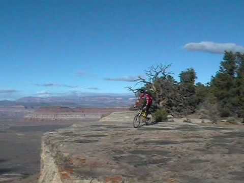
Chad Hunter pauses his K2 on the edge of the Shinarump caprock at the mesa's west end. To the north, Gooseberry mesa rises above the valley floor. Photo by Bruce November 11, 2001. Latest update to this page May 2023.
Little Creek MesaLittle Creek Mesa is a flat-top mountain 18 miles east of Hurricane.
It's just a few miles
south of its more famous twin
Gooseberry Mesa
. Little Creek has
a mix of singletrack, areas
of open rock, and some tech challenges. I highly recommend it for
expert riders and strong upper-intermediates.
The riding season starts around mid April and lasts through November. In the spring Little
Creek Mesa stays wet longer than other trails in southwest Utah. Pre-season
riding or riding
after spring rainstorms will damage the trail.
(Little Creek is considered an environmentally sensitive area by the BLM.) To help keep Little
Creek open to bike riding, go only when conditions are dry. Over the Edge
Sports (76 E. 100
S., Hurricane) is happy to provide current trail conditions. Call 435-635-5455.

There are stretches of firm dirt singletrack with studded with rock, alternating with sections of open rolling sandstone. The trail winds through pinion and juniper.

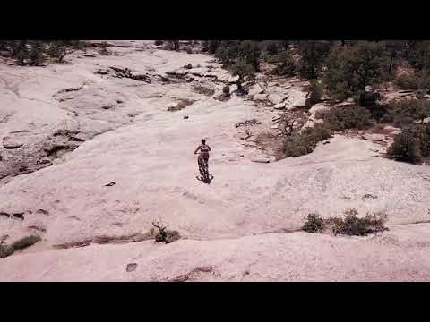
Bruce rolls across a sandstone canyon on Magic Carpet Ride in this 2023 photo.
The singletrack portions pass through pinion, juniper, and gooseberry. The trail zigs and zags
over small outcrops of rock, and is fairly (but not horrendously) technical.
The least technical
major route is the out-and-back on Magic Carpet Ride to North Point, followed
by the West Mesa
loop. The most-technical riding -- and the most confusing navigation --
is on the eastern side.
The open rock is rolling sandstone and conglomerate of the Shinarump member of the Chinle Formation
(Triassic Period, about 245 million years ago). This is great rock riding,
without any long
brutal climbs. There are a gazillion stunt opportunities.

Jon, Jamie, and Keith cross a typical section of Little Creek's rock in 2001.
There are two interconnected loops of about 9 miles each. The western side (Main Loop or West
Mesa Loop) has more tree-lined cruising, while still offering plenty of
tech stuff. The eastern
half (North Point Loop, Eastern Loop) has more slickrock and more-difficult
tech stunts. It's
also more of a navigation challenge. When linked together at the midpoint,
the two routes combine
for 14 miles of advanced riding.

Westbound, we arrive at the fork where the Magic Carpet Ride forks north off the Main (West Mesa) Loop.

Matt takes a little air, outbound on the West Mesa Loop.
The ride starts at 5600 feet elevation. There's little vertical change over the course of the
trail. But constant up-and-down riding will add to significant climbing.
The 14-mile big loop
requires 1100 vertical feet of climbing.
In the slickrock areas, the trail is marked by cairns (small rockpiles). I've found the trail
to be easy to follow at times, and difficult on other years. The West
Mesa Loop (returning
via Magic Carpet Ride) now seems to be consistently well-marked and pretty
easy to follow.
Just an occasional head-turn to spot the next cairn.

Not a cairn. Compared to other trails in the region, Little Creek has a lot of flora and fauna. This old guy refused to budge from the middle of the trail. I scratched up my ankles in the brush while walking around.

An area of rain-soaked singletrack has been armored with rock slabs. Check riding conditions before going! 2011 photo.
The slickrock areas on the eastern side of the North Point Loop can be very hard to navigate.
If you don't know where you're going, you WILL get lost. I strongly recommend
a GPS track file,
navigation App, or an experienced Little Creek rider. In some areas on
the east side of this
loop, competing routes, and cheater routes, and "fun add-ons" create a
confusing sea of cairns.
Little Creek's easiest ride is an out-and-back via Magic Carpet to the North Point. The West
Mesa Loop (with return via Magic Carpet) is another popular and not-too-overwhelming
option.
These routes are fairly easy to navigate and can be done by newcomers
with just a map and riding
directions.

Chad takes a wheelie off a ledge. November 11, 2001.

Matt executes a bunny hop with a twist, with the cliffs of Zion National Park in the background. There's so much fun rock, it's hard to keep from playing around. Play on slickrock only -- on singletrack, stay on the trail.
Most popular (and my favorite) is the BIG Loop, combining West Mesa with North Point for 14
miles. But be prepared for delays and head-scratching as you try to navigate
southbound on
the east side of this big loop. It's not unusual to finish with an extra
2 miles, spent riding
in circles on the rolling sandstone looking for the way home. I strongly
recommend following
a GPS track.
Magic Carpet Ride to North Point (North Loop or out-and-back)
This ride is 9.2 miles round trip, mostly on singletrack. The major trail forks are marked
with signposts, so navigation is simple. The few areas of open rock are
non-threatening and
pretty easy to ride. This is the route I'd suggest for adventurous advanced-beginner
or early-intermediate
riders.

Trail intersection between the West Mesa Loop and Magic Carpet Ride. The trail in the photo heads to the North Point and sandstone canyon rides.

The sandstone canyon. Plenty of room to play, but please don't mark alternate routes -- route-finding is confusing enough as it is.
Like all the Little Creek rides, the Magic Carpet to North Point route starts with 0.15 miles
heading west on the same road you drove on. Turn right on singletrack
at the rockpiles and
head north through the trees. After 1/2 mile, you'll arrive at open rock
with cairns turning
you west (left). You may also see some cairns ahead on the right -- this
is the return from
the Big Loop. Go left. After another 1/4 mile, you'll come to a trail
marker sign. Fork right
and veer right again off the old DT after 0.1 mile.
After 1.3 miles of Magic Carpet Ride, fork right toward "North Loops." When you come to an
open slickrock area 1/3 mile later with a trail-post in the middle, fork
left and find continuing
singletrack at the northeast corner.

View northwest toward the Pine Valley Mountains from the singletrack to the North Point.

Chad, Mike, Dominic, and Matt appreciate a viewpoint along the east-side trail from North Point.
After another 1/3 mile, you're at a slickrock ridge, looking north at a broad rock valley.
Obey the signpost and keep left, finding the continuing singletrack in
the trees. Now simply
ride another couple of miles to the North Point.
This is where you turn back if you're doing the upper-intermediate ride. For a much more difficult
return -- and an expert-level ride -- stay on the North Loop and return
via the technical sandstone
on the eastern side.
West Mesa Loop (with Magic Carpet Ride to close loop)

The singletrack is rarely "just dirt." Lots of sandstone.
This 9.5-mile route is a favorite for intermediate riders. The tech challenges are manageable
and there's a lot of nice cruising on tree-lined singletrack. The singletrack
is interrupted
regularly by rock outcrops that are fun playgrounds. It will arrive at
the western cliffs for
awesome views, then curve back to join Magic Carpet Ride for the return.
Head west at the slickrock fork at mile 0.4, and keep straight at the next fork at mile 0.8
where Magic Carpet Ride heads to your right. Now just follow the trail
until you come to the
fork at the north end of Magic Carpet Ride. Turn right (south) and head
home.

We're approaching the North Point. Ahead is Gooseberry Mesa. And below.. Really? A golf course?

Bruce rolls along the edge of the cliff. We're a bit less than half-way through the west loop at this spot.
At the northern Magic Carpet Ride fork, riders who are still looking for a whole bunch more
can head left to do the Big Loop. Warning: those last 7 miles have many
times the tech factor,
and will take you twice as long as the first 7 miles.
Or if you just want a tiny bit more tech, you can go left toward the North Loops, but then
keep right at the next fork in 1/3 mile. Drop into the slot canyon. You'll
get more tech (but
similar distance) by catching this eastern half of the main loop for your
return to the trailhead.

Dipping through a gap between sandstone platforms riding clockwise toward the cliffs.

Another drone shot of the west cliffs. There are some tech spots that are right on the edge of the cliff. Proceed with caution.
If you continue on to the north toward The Point and the North Loop, you're doing the "Big
Loop" (see below). While it doubles your miles, it more than triples your
effort. Only conditioned
experts (with plenty of water and calories) should do this.
The Big Loop (West Mesa Loop plus North Loop)
This 14-mile route is for advanced riders, or for conditioned upper-intermediates who have
a lot of time and a sense of adventure. Follow the West Mesa Loop to the
Magic Carpet Ride
fork, but go left (north) toward the North Loops. At the open slickrock
area, go to the trail
signpost and fork 90 degrees left. At the next open rock area, go to the
trailpost and veer
left to find singletrack in the trees. Follow this trail to the North
Point.

View down from North Point.

A spot you don't have to ride. There's an alternate line around this stunt.
Immediately after turning south from North Point, the trail gets rougher and many times more
technical. Make your way south and enter an area of slickrock mounds.
Some spots are tricky.
Follow the cairns. As you reach the bottom of the broad slickrock area,
ignore any cairns you
can see in the far distance ahead. You need to cross the wash to your
left and begin climbing
east. You'll pass a "cheater route" joining you on the right from the
last trail fork.
At the top of the hill, turn south and navigate along the edge of the trees. As the treeline
turns eastward (left), follow that curve and find the line of cairns on
the far side. Don't
be suckered into going up and over the ridge. You'll wind up back at the
ridgeline trail fork.

The east-side slickrock between North Point and the Waterfall has the most-difficult riding of any trail segment.

Chad drops six feet off the top of a cave. Don't try this at home.
Now continue south. The trail will turn west along the edge of a slot canyon. Follow it until
you can ride across, then turn back east along the edge. Rock piles mark
the spot where you
must drop steeply into the slot canyon.
Now follow the slot canyon bottom. It will make a tight turn and drop over a rock ledge (The
Waterfall). Continue straight through the main wash and climb the other
side.
As you arrive at the top of the climb, immediately fork right. (There are occasionally cairns
marking an alternate route on the left. Many many riders -- including
me, despite having been
there before -- have gotten lost on this alternate route and wound up
bushwhacking back toward
the mesa road.)
Follow the trail a mile back to the first fork.

Mike slips through the slot and turns to the Waterfall.
Ride Notes, West Mesa Loop with Magic
Carpet clockwise (easier), 9.5 miles:
0.0 Continue west on doubletrack from parking
0.2 R uphill on ST into trees N37 03.582 W113 13.664
0.5 Cross faint doubletrack, arrive at open rock
Fork L at N 37 03.821 W 113
13.606, westbound
(Straight = to North Loop)
0.8 Marked fork in flat washbottom
Go straight N 37 03.737 W 113
13.994
R = Return trail (Magic Carpet
Ride)
3.6 Reach western edge of mesa, north along cliffs
N 37 04.166 W 113 15.154
5.0 Trail veers eastward
6.0 Southbound
6.9 Drop into fork of Gould Wash
briefly
N37 04.701 W113 13.602
7.3 Trail fork, R to Magic Carpet Ride
N 37 04.488 W 113 13.405
(L
= to
north loops or larger loop, see
below)
8.2 Trail crosses open rock canyon to your left
8.4 Join doubletrack, straight downhill
N 37° 03.797' W 113° 13.792'
8.6 Back at trail fork (0.8) N 37 03.737 W 113 13.994
L in bottom of wash, follow
slickrock
8.9 Back at first trail fork (0.5), R on original path
9.5 At parking
*The West Loop has a fair amount of soft dirt surface. It's late to dry in the spring, and
turns to slop with rainstorms. Do Not Ride it when wet!
Full Main Loop, clockwise (about same
distance, but significantly harder), 9.6 miles:
Follow
West Mesa Loop (above) to mile 7.3
7.3 Fork L toward North Loops
N 37 04.488 W 113 13.405
7.6 Open rock area, trail sign N37 04.552 W113 13.162
R (straight) southeast
7.7 Trail drops steeply into bottom of rock wash
N37 04.520 W113 13.081 (follow
washbottom)
7.8 Waterfall, cross Gould Wash, steep
climb out
7.9 Critical spot! Fork R just
after finishing climb
N37 04.418 W113 13.004
(L = occasionally marked
alternate routes)
8.4 Alternate rejoins on L N37 04.129 W113 13.271
9.0 Keep straight (L) at original trail fork
N37 03.818 W113 13.599
9.6 Back at car
Big Loop clockwise, West Mesa and North
Point (tough), 14 miles:
Follow West Mesa Loop (above) to mile 7.3
7.3 Fork L toward North Loops
N 37 04.488 W 113 13.405
7.6 Open rock area, trail sign N37 04.552 W113 13.162
Fork R (northeast)
find ST at corner of slickrock
7.8 Ridge, looking at slickrock ahead and on R
N37 04.694 W113 13.046
Keep L and climb into
trees on ST
(R = two shortcuts E
and
NE)
9.6 At North Point, trail turns south
N37 05.697 W113 12.386
10.5 Trail more tech, harder to follow
11.4 L to cross bottom N37 04.787 W113 12.816
Climb uphill east
11.5 Shortcut rejoins on L, stay straight and uphill
N37 04.740 W113 12.767
Turn 90 degrees R at
top
of hill
11.7 Confusion of cairns. Stay
southbound near trees
11.8 Veer L and downhill N37 04.633 W113 12.949
(R up = cheater route
to
fork at 7.8)
Cross to opposite side
along treeline
12.0 W along edge of slot canyon until it's shallow
Cross over N37
04.531 W113 13.096
After crossing,
turn L (east)
12.1 Drop into slot canyon, follow bottom east
N37 04.520 W113
13.081
12.2 Waterfall, cross Gould Wash, steep climb out
12.3 Critical spot! Fork R just after finishing climb
N37 04.418 W113
13.004
(L = occasionally
marked alternate routes)
12.8 Alternate rejoins on L N37 04.129 W113 13.271
13.4 Keep straight (L) at original trail fork
N37 03.818 W113
13.599
14.0 Back at car
North Point Loop counterclockwise (tough,
harder to navigate), 8.7 miles:
0.0 West on doubletrack from parking area
0.2 R off DT onto ST N37 03.582 W113 13.664
0.6 DT then open rock, keep straight (R)
N 37 03.821 W 113 13.606
(cairns going L = to West Mesa
Loop)
1.1 Fork at end of rock area, keep left
N 37 04.157 W 113° 13.255
(R = "adventures in being
lost")
1.6 Fork in trail, go left and downhill
N 37 04.714 W 113 13.019
(Right = another good way to
get lost)
1.7 Up waterfall into canyon
Climb steeply L out of slot
canyon
1.8 Turn R through dip N37 04.531 W113 13.096
(straight = to west Main Loop)
Then R (east) to follow edge
of
slot
2.0 Large open rock area, follow contour north
(Cairns are often confusing)
Avoid shortcut on L at N37
04.633 W113 12.949
2.5 Turn left and drop west into slickrock canyon
N 37 04.719 W 113 12.754
Left and up = shortcut to return
loop
2.6 Across wash then right
4.3 North Point N37 05.697 W113 12.386
6.0 Open rock, keep L and south
N37 04.694 W113 13.046
(R = shortcuts to outgoing
trail)
6.3 Cross open rock, R after ledge
N37 04.552 W113 13.162
(L = shortcut to slot canyon,
Waterfall)
6.6 L on Magic Carpet Ride
N 37 04.488 W 113 13.405
(R = West Mesa Loop)
7.5 Trail crosses open rock canyon to your left
7.7 Join doubletrack, straight downhill
N 37° 03.797' W 113° 13.792'
7.9 Trail sign N 37 03.737 W 113 13.994
L in bottom of wash, follow
slickrock
(R = West Mesa Loop)
8.2 Back at first trail fork (0.5), R on original path
8.7 At parking
Out-and-back to North Point via Magic
Carpet Ride (easiest), 9.2 miles:
0.0 Continue west on doubletrack from parking
0.2 R uphill on ST into trees N37 03.582 W113 13.664
0.5 Cross faint doubletrack, arrive at open rock
Fork L at N 37 03.821 W 113
13.606, westbound
(Straight = to North Loop)
0.8 Marked fork N 37 03.737 W 113 13.994
R on Magic Carpet Ride
0.9 Veer R off DT
2.2 Trail fork, R to North Loops
N 37 04.488 W 113 13.405
2.5 Open rock area, trail
sign N37 04.552 W113 13.162
Fork R (northeast)
find ST at corner of slickrock
2.8 Ridge, looking at slickrock ahead and on R
N37 04.694 W113 13.046
Keep L and climb into
trees on ST
(R = two shortcuts E
and
NE to eastern trail)
4.6 At North Point, trail turns south
N37 05.697 W113 12.386
Turn around, backtrack to start

Little Creek topo map
Getting there: On Highway 9 at the east end of
Hurricane, turn south on US-59 and zero your odometer. One block later,
turn left (east) and begin climbing up out of the Hurricane Valley. 13.2
miles later, turn right on gravel road. 14.1 turn right; 14.9 keep right;
16.0 keep left; 16.4 keep left; 18.5 continue straight across cattleguard; 19.5 turn right (critical
turn where corral is on your left, leave the main road); 20.1 bear left. At 21.0, cross 3rd cattle guard; 21.5 road
reaches slickrock, park here (GPS N 37° 03.586' W 113° 13.528'). Begin
the ride by heading down the road (the singletrack forks off on the right
0.2 miles later).
Latest update 2011