
Lazy EZ Loop Trail
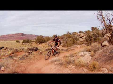
The Lazy EZ loop is a popular part of the "Brand Trails" system just north of Moab. On weekends, expect lots of riders. This 3.1-mile lariat-shape singletrack loop is inserted inside the Bar M loop. The mellow riding is suitable for early intermediates and competent beginners. There's a bit of mild up-and-down for around 150 vertical feet of climbing. It's a great trail for those just getting started with singletrack.
The northern end of Lazy-EZ forks off the doubletrack "Short Loop", just 1/10th doubletrack mile from the main parking area. Fork right. (On the left is the North 40 trail.) After 0.1 mile, the trail splits into Lazy (eastern trail) and EZ (western). The loop is designated as a one-way ride starting with EZ, so go to the right.
After about 1.5 miles the trail will reach the Bar M loop. Beginners can loop back on the easy bike path if they're already tired. If you plan to exit the Lazy-EZ loop, keep right. To continue the loop, go left.
 follows the break between the rock hill and the valley.")

The southern end of EZ also connects to the singletrack Deadman's Ridge (Deadman's Ridge is an advanced tech trail. It joins the Bar B a little bit from its origin on the south end of Bar M, then continues in an arc around to the paved bike path from Moab to Highway 313.)
Because of the popularity (read: crowding) of this trail, it's now a one-way counterclockwise ride. So even through riders call the loop Lazy-EZ, it's actually EZ-Lazy if you're riding the loop from the main parking area.


The singletrack is smooth. For the most part, the few rock outcrops are mellow enough for beginners to bump across with butt firmly on the saddle. It's a good trail to start learning get-yer-butt-off-the-saddle skills. I don't remember any areas that should make kids or their Moms nervous.
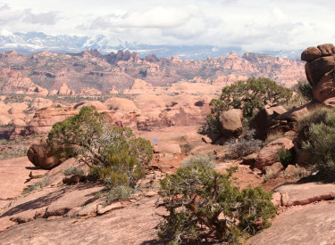
From Lazy, there are views to the southeast of the La Sal Mountains. Directly east are the domes of Entrada sandstone in Arches National Park.
EZ offers views of the Wingate cliffs across the highway to the west. EZ has a little more interesting riding surface as the trail hugs the edge of a small ridge.


The Lazy-EZ loop will be used by riders of all skill levels. For the beginner, it's nice non-threatening singletrack, long enough to be satisfying yet not exhausting. For experts, it's a more interesting way to get from the Bar M parking down to the expert-level trails on the south and east: it creates a singletrack route through to Deadman's, Bar B, and Rockin A.
0.0 Exit parking southbound on DT N38 39.223 W109 40.468
0.3 Fork L on "Bar M Short Loop" DT N38 39.008 W109 40.291
0.6 Fork R off DT onto Lazy-EZ singletrack N38 39.187 W109 39.990
0.7 Keep R for counterclockwise loop on EZ
N38 39.169 W109 39.855
2.0 Stay L on main trail; don't go to DT yet
2.1 Temporarily join DT eastbound (Left)
N38 38.574 W109 39.310 (option: Deadman's Ridge across DT)
150 feet later fork L onto Lazy ST N38 38.573 W109 39.280
3.6 Rejoin EZ, keep R and northbound
3.7 Back at DT, go L
4.0 R on DT northbound
4.3 Back at parking


Getting there: From the north, exit I-70 at
Cresent Junction and drive south on US-191 for 22 miles. From Moab, drive
7 miles north from the Colorado River on 191. When you see the Gemini
Bridges parking area, look for a gravel road on the opposite side (east,
away from the cliffs). Turn onto the gravel road and immediately go right.
Pass the first parking strip. Just south is parking for the Bar M, which starts by riding the gravel road south.
But keep going until the gravel road turns left (east) near a trail kiosk
and roll down to the big parking lot in the valley.
From Moab, ride the Old Highway 191 (paved trail) until you
reach the Bar M sign. Then, instead of ducking under the road, step
through the break in the fence on the right. The gravel trail is the
Bar M trail. Get on the eastbound gravel road and head for the parking
lot. The "Short Loop" trail heads east from parking.
Bathroom: At main trailhead. Water: None.
Riding resources for this trail:
Single-page riding guide
GPS track files (right-click and "Save as..."):
GPX all Moab Brand area
trails
Lazy-EZ only
High-res topo for printing (500 KB):
View
Lodging, camping, shops:
Links to Moab area resources