Twist and plunge about half-way down Gravitron. Photos and review from a ride by...
Twist and plunge about half-way down Gravitron. Photos and review from a ride by Bruce on November 12, 2014. Updated November 2017.
Gravitron and VertiGo
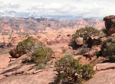
Advanced-technical trails in the Klonzo system

These two advanced-level trails were completed in late fall 2014. They make a nice addition to the Klonzo and South Klonzo system, which previously offered only intermediate-skills riding. They lie at the far northern edge of the riding area. There are 22 named trails in this system, with many of the newer trails being split between very easy biking and upper-intermediate to advanced riding. 

Gravitron
Gravitron is just under two miles in length. It drops 300 feet of absolute altitude over that length, but the up-and-down nature of the trail yields 600 feet of total descent. It's a one-way trail -- because of higher speeds and blind spots.
The first turn on the trail. Slabs of rock armor the banked turn and the hit at ...
The first turn on the trail. Slabs of rock armor the banked turn and the hit at the bottom of the wash. Then it's up the other wide and a quick right turn to plunge through the wash again.
Looking southeast, as the trail hugs the skirts of an arm of the mesa.
Gravitron is fairly straight-forward to ride, requiring advanced but not expert skills. It's not tricky. The plunges are only moderately steep and always short. It's great practice for how you put your weight on the bike and guide it through turns.
All but a tiny bit of the trail is narrow dirt ribbon. There's one patch of slickrock and occasional rock-slab armor of plunges and wash-crossings. The rest is dirt.

The trail begins at the highest point of the Wahoo loop. If you're riding counterclockwise (the recommended direction), you'll fork to the right just after the trail turns back from eastbound to westbound.

On the few spots of open rock, purple stripes show the way.
Looking back. Hit the slot as you come up from a dip, then find the right line t...
Looking back. Hit the slot as you come up from a dip, then find the right line to avoid banging the rocks below.
There are a couple of spots where the line becomes critical. If you fishtail in loose dirt or bobble as you steer, you'll bang something at trailside.
This is a great trail for "doing laps." After you test it once, head back east on VertiGo, turn left onto a tiny piece Cross Canyon, then climb clockwise around Wahoo to do it again. You'll have more confidence to hit the rare spot that made you nervous.
A little drop hides in the shadow of the rock. No need to scout it; its tiny.
A little drop hides in the shadow of the rock. No need to scout it; it's tiny.
Temporarily on top of a small mesa, were looking south.
Temporarily on top of a small mesa, we're looking south.
The trail is constantly in motion; up, down, side to side.
But instead of curving around the slopes, Gravitron rolls over countless little humps and through a gazillion little washes.
One of a series of plunges through tributaries to the main wash. The white spot ...
One of a series of plunges through tributaries to the main wash. The white spot is glare from a chunk of agate that's caught the sun.
Getting close to the bottom, as were about to run beneath some interesting rocks...
Getting close to the bottom, as we're about to run beneath some interesting rocks.
At two miles, Gravitron is the longest continuous stretch of trail in the Klonzo system.
At its far end, Gravitron climbs up the side of a ravine to the middle of the VertiGo Trail. From here, right takes you downhill while left sends you over to the Wahoo loop so you can do it again.
Trails end. A bit of a climb to finish of Gravitron. Theres some rough rock to a...
Trail's end. A bit of a climb to finish of Gravitron. There's some rough rock to as you approach the turn to VertiGo.
VertiGo
Typical terrain on the northern half of Vertigo.
VertiGo is 1.1 miles in length. It has a very different personality than Gravitron. Rather than a plunge and dip, it's more of a bike-handling challenge. But it's not too tricky, either. I'd rate it as an upper-intermediate to early-advanced trail.
VertiGo arcs from the middle of Secret Passage on the south to Cross Canyon on the north. The north end is just a tiny distance from the Wahoo loop. Eastbound, it serves as a route to the top of Gravitron.
A duck-under rock. Marked appropriately enough, with a rubber ducky on top of th...
A duck-under rock. Marked appropriately enough, with a rubber ducky on top of the warning sign.
Heading southwest as we ride laps.
In either direction, VertiGo offers its own version of a loop ride by using Secret Passage and Cross Canyon to complete the circle.
There are many great ways to combine these trails into a ride of Klonzo. But you'll definitely want to add Gravitron and VertiGo to your plans.

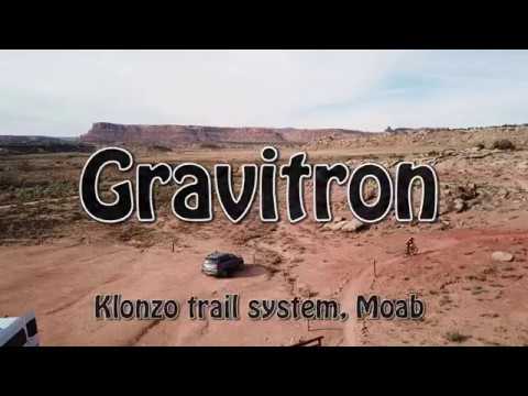
See the Zephyr trail page for a longish pedal-fest from the Brand Trails to the top of Gravitron and back. It's 25 miles, 2300 vertical feet, and takes a conditioned rider about 4 hours.

Near the southern end of VertiGo after the Gravitron trail fork, the trail hugs ...
Near the southern end of VertiGo after the Gravitron trail fork, the trail hugs a steep hillside.

Gravitron and Vertigo loop ride...

[Back to video list ]
map
Klonzo northern trails riding map.
Getting There:  To safely navigate Willow Springs Road, I strongly recommend an SUV. A low-clearance sedan may have problems with ruts and sand.
Western (main Klonzo) Trailhead: Willow Springs Road forks east off Highway 191 18 miles south of I-70 and about 10 miles north of Moab (1.8 miles north of the junction with Highway 313 (to Canyonlands and Dead Horse Point). Turn onto Willow Springs Road. Keep straight as spurs go to camping areas. At mile 1.4, turn left to cross Courthouse Wash (may not be passable in wet weather). At mile 2.0 pass the Sovereign Trail parking area, a flat area outlined in rocks on the left (north) side of the road N 38° 41.876' W 109° 39.868', with a natural gas pump building on the right. At mile 2.7, turn left off Willow Springs Road onto a small doubletrack. 100 feet later, park and begin your ride. The trail on the left takes you clockwise and immediately to the slickrock.
Eastern (Borderline) TH: Keep going on Willow Springs Road past the west trailhead. At mile 3.0 from US 191, turn left on doubletrack. Drive 0.2 miles to a small area of slickrock. The trail to the left goes toward the western trailhead. Right climbs up for a counterclockwise loop.
Midway Trailhead: Keep on Willow Springs Road past the first trailhead, then keep right at the fork about 1/10 mile later (at mile 3.0 from US 191). A half-mile after passing the spur to the main trailhead, there will be a few parking spots on your right at the entry to the Midway trail.
Dinosaur Tracks:  Not really a mountain bike trailhead, but if you're not pedaling past, it's worth a visit. Head for the Midway Trailhead as above. Drive past Midway as the road climbs. 1/4 mile past the Midway Trailhead, the road curves around a cleared area on sandstone, and you'll see a sign on your right explaining the tracks.
Redhot (Houdini) Trailhead:  On Willow Springs Road, pass the spur to the main trailhead and keep right at the fork in the road, passing the spur to the second (Borderline) trailhead. Pass the Midway trailhead and the Dino tracks. A mile past the main trailhead, there's a cable fence on your right. The Zoltar trail is on your left and Houdini is on the right. There's enough room here for a car or two, but be sure you aren't blocking access to the 4x4 route to the left of the Houdini trail entrance.
Carousel Trailhead:  This is a good starting point for young children (including stroll-a-bikes) and very out-of-shape true beginners. Go to the Redhot trailhead as above. Now turn 150 degrees hard right and descend the broad path marked with white and red stripes. The red stripes will head up onto singletrack, leaving only white stripes. A half-mile after leaving Willow Springs Road, the path will enter a parking area outlined by a post-and-cable fence. Park here. The trail passes directly through this parking area on each side.
Brand Trailhead (pedal by bicycle):  See the Zephyr Trail page.
Riding resources for this trail:
Other pages for this trail system:
   Klonzo North page
   Klonzo South page
   Beginner slickrock page
GPS track files (right-click and "Save as..."):
   GPX area tracks
   Gravitron only
   VertiGo only
Maps for printing:
    Klonzo area topo
    Trail Mix PDF Map
Lodging, camping, shops:      Links to Moab area resources
Bathrooms and Water: None at Sovereign or Klonzo
Camping: Primitive spots along Willow Springs Road. Commercial camping across from 313.
Nearest supplies: Gas and quick-stop on 191 across from 313, 1.7 miles south of Willow Springs road.