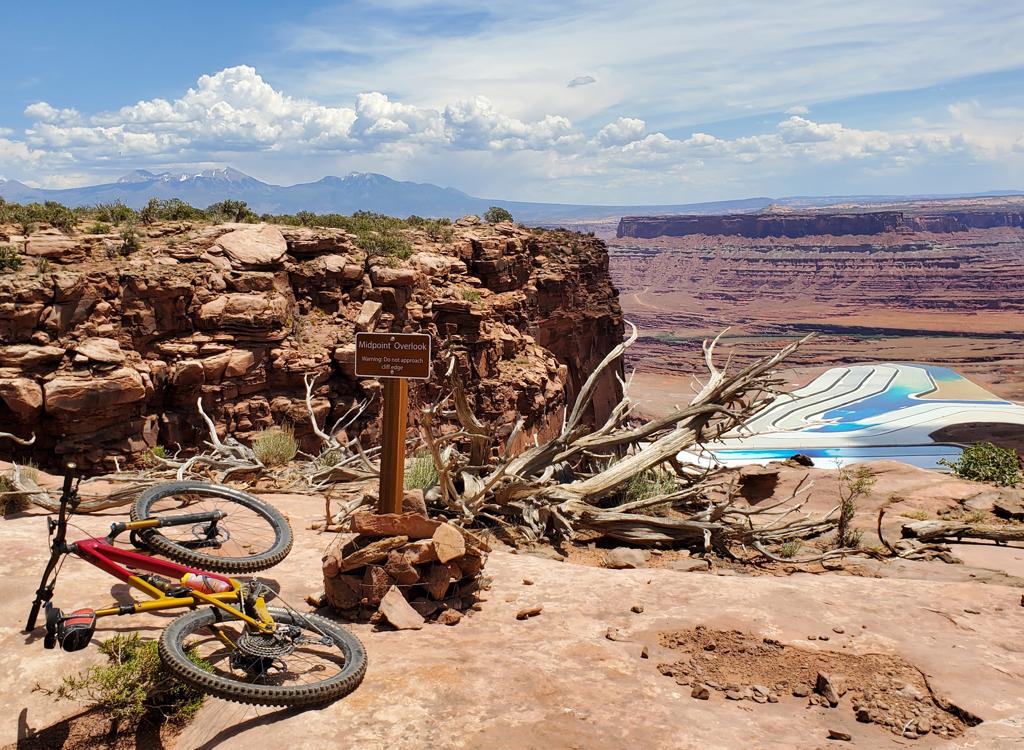
Matt stands at one of dozens of viewpoints on Golden Spike. To the south, the dark line is the canyon of the Colorado at the entrance to Moab. Photo and review by Bruce, May 17, 2002 with latest update 2016.
Golden Spike
Here's the good news: The Golden Spike Trail runs on tilted Kayenta bedrock. This type of sandstone forms gazillions of ledges, so there are stretches of smooth stone alternating with drop-offs and uphill ledge attacks. This trail is a technical-rock lover's dream -- 7 miles of up-and-down hard-hitting tech riding.
Here's the good news: The Golden Spike Trail runs on tilted Kayenta bedrock. This type of sandstone forms gazillions of ledges, so there are stretches of smooth stone alternating with drop-offs and uphill ledge attacks. This trail is a technical-rock lover's dream -- 7 miles of up-and-down hard-hitting tech riding.
Now the bad news: To ride Golden Spike, you need to get there. That means you have to climb
up the
Gold Bar
Singletrack
, the
Gold Bar 4x4
or
Poison Spider Mesa
trails. On your bike. These trails, with their ledges and stiff climbs, will get first crack
at you. By the time you hit the stunts on Golden Spike, you'll be a whimpering
jelly-legged
wannabe. Or maybe not. But I warned you.

Handlebar view as we climb uphill -- yet again -- on Golden Spike. White spots painted on the rock mark the trail.

View southwest toward the Colorado River.
The Golden Spike trail undulates up to the edge of the cliffs, then backs away, again and again.
Tough technical climb followed by technical descent. Fun, if you have
the strength left to
attack. The trail never seems to be level. It's always climbing uphill
or descending.
The Golden Spike forms the 5th trail segment of the new epic Magnificent 7, a ride of 26 miles from Gemini Bridges road at Highway 313 to the end of the Portal Trail. For information on riding this route, see the Magnificent 7 page . Many riders substitute the newly-approved Gold Bar Rim singletrack route for Golden Spike.

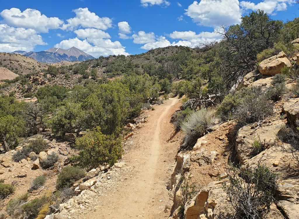
As we climb once again back towards the rim, the La Sal Mountains form the background. April 2011.

Mike watches Matt repair his 3rd flat in the days before tubeless tires. When there aren't views off the cliffs on the east, there are fantastic views of canyons and mesas to the west. May 2002.
To reach the Golden Spike Trail from the
Gemini
Bridges
trailhead, you'll follow the
Gold Bar
4x4
or
Singletrack
trail. This is 8.5 miles (5 easy, 3.5 tougher) with about 1500 total feet of climbing. Just
before the viewpoint that marks the end of Gold Bar, you'll turn right
as the Golden Spike
begins.
To get to the Golden Spike via
Poison Spider
Mesa, you'll climb about 800 feet, then gain and lose a few hundred as you push over the Navajo
sandstone domes of Poison Spider. As you follow the little "Jeeps" painted
on the rock, the
Golden Spike trail forks left at about mile 7.5.

Mike launches off a ledge.

The Golden Crack. You'll share the Golden Spike with motorcycles and 4x4s. Motos usually drive the trail south-to-north.
The northern half of the trail is almost all slickrock. On these slickrock areas, the trail
is well-marked with painted spots on the rock. (You may see older faded
painted "spikes" as
well.) The occasional short side-trail to the rim is usually well-marked.
This trail is remote. Some days, you may not see anyone else on this trail. Be sure you're
well-prepared with plenty of water, food, tools, and spare parts.

Matt shreds 4 inches of tire jumping the Golden Crack. What do you do with a 4-inch slash along the rim? Wrap the new tube with strips of old inner tube, glue a piece of old tube to the tire casing, add duct tape, and strap the tire down with cable ties around the rim. He rode it back to Moab.

View north from a viewpoint on the Golden Spike. There are several.
Golden Spike tilts from north to south, losing about 700 vertical feet. But you'll put in 1500
feet of climbing when riding north-to-south. For every 100 feet you descend,
you'll climb another
70 feet back uphill. Over and over. The Gold Bar to Golden Spike to Poison
Spider route is
a monster ride, over 20 miles point-to-point with 4000 vertical feet of
climbing.
At the southern end, the character of the trail changes. You'll ride over red dirt and ridged
mudstone. You'll roll over domes of Navajo sandstone and drop into a wash
between cliffs of
sandstone. Then you'll hit a sandy stretch, which some riders avoid by
catching a connector
to Poison Spider found at mile 5.5 of Golden Spike.

Descending Navajo sandstone into a shady wash, as a couple of powered riders lead the way.

Nearing the end of Golden Spike, as domes of sandstone alternate with sandy stretches.
A shorter version of the Golden Spike ride involves climbing
Rusty Nail
You'll avoid about 300 vertical feet of climbing and cut a couple of miles off the trip.
Riding notes, north to south:
0.0 South from Gold Bar below overlook
N38 36.846 W109 38.533
0.8 Keep L (Downhill R to Rusty Nail)
N38 36.511 W109 38.245
0.9 Golden Crack N38 36.509 W109 38.138
1.2 Back to Rim N38 36.549 W109 37.554
2.4 Turn away from rim N38 36.204 W109 36.887
0.0 South from Gold Bar below overlook
N38 36.846 W109 38.533
0.8 Keep L (Downhill R to Rusty Nail)
N38 36.511 W109 38.245
0.9 Golden Crack N38 36.509 W109 38.138
1.2 Back to Rim N38 36.549 W109 37.554
2.4 Turn away from rim N38 36.204 W109 36.887
2.9 Stay L N38 35.883 W109 36.816
3.2 Back to rim N38 35.875 W109 36.510
4.1 Keep L N38 35.299 W109 36.472
5.5? L for Portal Connector (exact spot not noted, sorry)
6.7 At Poison Spider N38 33.710 W109 35.788
L for Portal, R to descend Poison Spider
3.2 Back to rim N38 35.875 W109 36.510
4.1 Keep L N38 35.299 W109 36.472
5.5? L for Portal Connector (exact spot not noted, sorry)
6.7 At Poison Spider N38 33.710 W109 35.788
L for Portal, R to descend Poison Spider

Map of Golden Spike
Getting there, Gemini Bridges - Gold Bar Rim Trailhead: Drive south on US-191 for 16 miles
south of I-70 (about 15 miles north of Moab). Spot the parking area on the
west (right as you head toward Moab) side of the road. GPS N 38° 39.381'
W 109° 40.672'. Park in front of the railroad tracks, and head out west
on the road.
Poison Spider trailhead: Go 6 miles down U-278 then right up a short dirt road with a sign that says "Dinosaur Tracks." GPS is N 38° 31.917' W 109° 36.473'.
Poison Spider trailhead: Go 6 miles down U-278 then right up a short dirt road with a sign that says "Dinosaur Tracks." GPS is N 38° 31.917' W 109° 36.473'.
Riding Resources:
One-page printable trail guide
GPS track files (right-click and "Save as..."):
Magnificent 7
path
Mag 7 area
master GPX file
GPX Golden Spike area tracks
GPX route Golden Spike 4x4
Topo maps for printing:
Low-res
Gold Bar to Poison Spider
High-Res
Golden Spike
Magnificent 7 low-res
Lodging, camping, shops:
Links to Moab area resources