View from Brian Head Peak, looking south towards Cedar Breaks. Initial photos and ride report July 27, 2001 by Bruce. Latest update September 16, 2022.
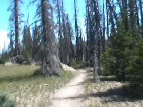
Dark Hollow Trail
The Dark Hollow Trail is an upper-intermediate ride in the Brian Head area. Trailhead elevation
is 11,000 if you start from the shuttle parking area. You'll need to ride
a bit of the Sidney
Peaks trail to get there. Just about everyone does this ride with a shuttle,
but there's a
loop ride option I'll discuss below.
The Dark Hollow trail consists of 6 miles of singletrack dropping 2200 vertical feet from the
Sidney Peaks trail, then 6 miles of doubletrack in Second Left Hand Canyon
out to Highway 143,
with another 2300 feet of elevation loss. Because of the elevation and
north-facing slopes,
the expected riding season is July through October.

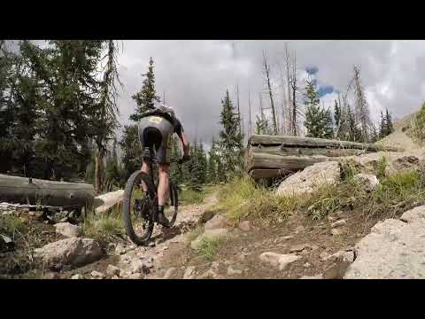
Riding down a more gnarly stretch. The first 1/4 mile of Dark Hollow is definitely expert-level, and most riders will walk this stretch.

Trail view in a burned area in 2022. The re-growth is a slow process.
NOTE! In 2017 this trail was burned and then flood-damaged. It was rebuilt and reopened in
2021. The top mile follows the old route (and can be steep), while the
rest is newly built.
And while the dirt road in Second Left Hand Canyon (lower Dark Hollow)
used to be plush, it's
regularly damaged by flooding from the burn scar.
Trailheads and Connections

Drone view of the trailhead on the Brian Head Peak road.
Brian Head Peak trailhead
Most riders will get to the trail when their shuttle vehicle drops them off at the Brian Head
Peak trailhead. This trailhead is located on the gravel road to Brian
Head Peak, which starts
on Highway 143 south of Brian Head. At 1/4 mile past the "summit" sign,
turn left and drive
1.8 miles to the parking and shuttle drop-off area on your left. The Sidney
Peaks trail is
just uphill and across the road. It will be 1.1 miles to the top of the
Dark Hollow trail.

Parking spot at the end of the singletrack at the Second Left Hand Canyon road.
From Second Left Hand Canyon
The shuttle pickup for Dark Hollow is where the doubletrack portion of the ride meets Highway
143, just 3.9 miles from the middle of Parowan -- or 9 miles downhill
from Brian Head. There's
room for a few cars to park just off Highway 143. If you drive uphill
6 miles on the Second
Left Hand Canyon dirt road, there's a small spot where up to 3 vehicles
can park at the point
where the singletrack meets the doubletrack. (Note: compared to before
the fire, the dirt road
is very rough, requiring a 4x4 high-clearance vehicle.) This spot can
be a good starting point
for doing a loop ride.

Yankee Meadows, looking north down the boat ramp. There's a picnic area and bathrooms at the reservoir.
Yankee Meadows
A better option for a loop ride is to drive uphill on the Yankee Meadows road. This road is
suitable for sedans, being half paved and half smooth gravel. You can
park at the reservoir
and pedal 1.5 miles to the intersection of the Second Left Hand Canyon
road with FR 048, then
continue uphill to ride the loop I describe below.

Climbing up Sidney Valley on the loop ride.
Sidney Valley Viewpoint
You can start from the opposite end of the Sidney Peaks trail by driving the Sidney Valley
road from Highway 143 to the viewpoint. Here you can pedal 3.2 miles up
Sidney Peaks to the
top of Dark Hollow. When done as a loop, this puts most of the climbing
at the end of the ride.
As a shuttled ride, this option is longer (both for the bike and for the
shuttle vehicle) and
has more climbing.

Bruce heads east on the Sidney Valley trail in 2019.
My description of the Dark Hollow trail will focus on the six-mile singletrack portion. Some
riders may feel slighted because they love to blast down the six miles
of doubletrack. My apologies.
First, you'll arrive at the top of the Dark Hollow trail via the Sidney Peaks trail. For most
riders, this is eastbound from the Brian Head Peak trailhead. It's 1.1
miles to the 4-way trail
intersection with Lowder Ponds and Dark Hollow, where you'll turn left.
If you're coming up
from the Sidney Valley viewpoint, it's 3.2 miles from the parking area.
Just 30 feet after forking away from Sidney Peaks, the Dark Hollow trail hits a quarter-mile
drop-in zone of technical stuff. The bike shop says most riders walk this
section. But for
an expert or upper-intermediate rider, it's not too tricky.

Rolling into the first turn on Dark Hollow. It's more techy than it looks in the video (see below).

Descending through embedded boulders and loose chunks.
After a tight turn and more boulders, you'll roll down into fir and aspen forest.
The "vertical mile" of Dark Hollow descends 5,300 feet to Parowan. Most riders go only to the
mouth of Second Left-hand Canyon at 6600 feet elevation. The length of
the combined singletrack
and doubletrack to the highway is 12 miles, but add 4 miles of paved road
if you're going into
Parowan.
Because Dark Hollow sees many fewer riders than Bunker Creek, it also receives less maintenance.
Watch for deadfall.
As you drop down Dark Hollow, the trail is often rough with embedded rocks. These sections
aren't very long, but they can be challenging to less-skilled riders.
Intermediate riders may
want to walk some of the more difficult sections of downhill.

A blow-down that took his friends down with him across the trail.

Early in the descent. We haven't reached the burn scar yet. The dead trees here are courtesy of a bark beetle 20 years ago.
Just after mile 0.6 of relatively rapid descending, you'll reach a flat meadow area (popular
with sheep), with the Paradise Canyon trail forking away to the right.
(In 2022, the Paradise
Canyon trail is hard to spot and it's "closed for repairs" from fire and
flood damage.)
Although only the first section is exposed to high-altitude sun and wind, I suggest a strong
sun-block. And because cold storms pop up most afternoons, pack a rain
slicker. (I keep one
in my under-seat pack, so I always have it.)
At mile 0.7, the trail will fall onto an old doubletrack for around 1/2 mile. This is the only
boring part of the ride. Watch for the right turn off the doubletrack
at mile 1.3, which in
2022 is marked with small temporary signs. The trail now becomes much
more interesting!
The only spot that wasn't marked with some sort of trail sign was the intersection of the singletrack
with the Second Left-hand Canyon road. Just remember that, for the shuttled
ride, you're going
downhill -- turn 180 degrees left at the road. (But if you want to go
uphill to Yankee Meadows
Reservoir, you can go down First Left-hand Canyon to the highway from
there. It adds about
2 miles.)

We're in the burn scar, as young aspens grow among the skeletons of their parents. From here downhill, the trail has been completely rebuilt.

A log ride at the side of the trail.
The trail will enter a long stretch of burn scar. This stretch of trail has been completely
rebuilt with bench cut technique. The tighter turns have tall berms and
there are frequent
swoops.
The trail spends a bit more time in undamaged forest than in the burn
scar, as the path winds around through banked turns. Dark Hollow is a
lot
of fun to ride. I prefer this trail over
Bunker Creek
.

Rolling through a banked turn in healthy aspen forest

Rocketing into a rolling stretch on a flat area.

The bench-cut technique that the trailbuilders used is obvious in this pass in dark fir and aspen forest.

Bench cut technique.
As you approach Second Left Hand Canyon, the grade of the trail lessens. There will be a bit
of climbing. You'll drop through a few small drainages. In the early season
-- or when it's
been raining -- these may be a deep splash.

One of the small splashes. But at least this one isn't a mud puddle.

View west into Second Left Hand Canyon as we get lower on the mountain.
At this point, you'll begin to see the red limestones of the canyon through the burned trees.
The trail then makes a drop to the doubletrack. If you're doing a loop
ride, head to your car.
If it's the full-shuttle ride, turn 180 degrees downhill on the dirt road.
Brian Head Peak is light-colored soft volcanic rock, deposited in the last 20 million years.
The bright pink cliffs of Second Left Hand Canyon are formed of Claron-formation
limestone
from about 40 million years ago during the Tertiary Era. This limestone
was deposited at the
bottom of a large fresh-water lake, before the plateau area was uplifted
away from the valleys
of the Great Basin. After a couple of miles on the surface volcanic deposit,
you'll drop through
an area of intrusive igneous rock (granite), before cruising through pink
dirt of the Claron
formation and some gray volcanic tuff (ash that settled to form a deep
layer).

View downhill on the doubletrack portion of the ride.

Rolling down the doubletrack at 30 mph in 2001. In the past those last 6 miles could be done in about 15-20 minutes.
It's 6 miles of doubletrack down to the highway. The trees change from spruce and aspen to
juniper, fir, pinion, and box elder. The doubletrack can be rough because
every little ravine
pours flood waters across the road. So it's no longer the smooth cruise
of days gone by --
as in this photo.

Cranking uphill on FR 048, in an area that's been burned.
While you can grind up Highway 143 after doing the full DH ride -- and I've done this -- I
don't recommend it. It's brutally steep and there's no significant shoulder.
Being hit by traffic
is a real risk.
Instead, I recommend a shorter ride with Forest Road 048 and eastern Sidney Peaks as your uphill.
FR 048
As noted above, there's a small clearing for parking on the Second Left Hand Canyon doubletrack
right across from the bottom of the Dark Hollow singletrack. If you have
a 4x4, you can drive
up the DT to this spot, or drop down from the Sidney Valley road after
climbing past Yankee
Meadows reservoir.
From the bottom of the singletrack up to the Sidney Valley Viewpoint is exactly 5 miles, with
1700 vertical feet of climbing.

For most of the climb, you're in a recovering burn area. There's no shade.

Looking west from FR 048.
There are only a couple of viewpoints as you climb FR 048, but it's worth stopping to take
a look.
Expect to have a few ATVs motor past as you pedal. And while there were no other mountain bikers,
I saw tire tracks that were fresh since a rainstorm 2 days previously.
The pitch of the climbing isn't too bad for a conditioned rider. There's a sustained climb
near the top that may make you drop into granny and spin.
When you hit the parking loop for the Sidney Valley Viewpoint, veer to the right on the singletrack
that skirts the border of the parking area to the north.

Looking south uphill during a grunt up to the ridgeline.

Looking toward the drop-off on the north side of the ridgeline on the Sidney Peaks trail. There are some views here.
Sidney Peaks westbound
You're now on the Sidney Peaks trail. You'll gain a bit of elevation as you ride west toward
the top of Dark Hollow, but most of your climbing will be up and then
down again. The overall
total of climbing will be around 600 vertical feet on this three miles
of trail, as you gain
around 400 feet in elevation.

Sidney Peaks was a hit-and-miss during the fire of 2017. Some areas are still relatively pristine...

While others are an other-worldly experience.
Watch for oncoming riders. They may not expect someone to be coming uphill.

Bruce rolls a turn as the trail winds through connifers.

Leaving the big meadow on Sidney Peaks. Just a mile more to the top of Dark Hollow.
At mile 3.2 from the Sidney Valley viewpoint, you'll arrive at the four-way trail intersection.
Turn to the right and drop down Dark Hollow.

The trail winds through aspen forest in this 2002 photo, near the fork to the Scout Camp Loop. Note that rehab of the Hendersen Lake/Scout Camp route is not complete as of 2022.
Bottom Line!
Very fun trail, although much more technical than Bunker Creek and -- perhaps because of that
-- less ridden. While usually done with a shuttle, a loop ride of the
upper (singletrack) portion
is a good choice.

Map showing access from FR 048 and Yankee Meadows.
Shuttle service:Shuttles are available from the bike shops at Brian Head. The cost per
rider will be around $25 (2018 price), with a two-rider minimum. (If
you're a single rider, you can request to go as an add-on by calling the
shop. You need to be
flexible about when you go. It's fairly easy to add yourself to a shuttle
run to Bunker Creek. But fewer riders go to Dark Hollow and on a given
day, there may not be ANY shuttles doing the Dark Hollow run unless you
buy enough tickets to make it happen.)
Note: Paradise Canyon and Hendrickson Lake (Scout Camp Loop) have not
yet been repaired and are not open at the time of this update.
Getting there, self-shuttle: Leave your shuttle car on U-143,
anywhere below Second Left-hand Canyon (the canyon is up the second gravel
road on the left after entering the canyon). GPS of the intersection of
U-143 with the trail is N 37° 47.931' W 112° 49.350'. On U-143, head up
the canyon from Brian Head to the summit. Just 1/4 mile past the summit
sign, turn left on a gravel road (GPS N 37° 40.136' W 112° 50.350').
Drive 2.5 miles to the peak of the mountain to start your ride. GPS is GPS
N 37° 40.904' W 112° 49.827'. (Note the parking area to your left at 1.8
miles. Once you start riding, you'll turn onto the singletrack across the
road.)
Bottom of singletrack for loop ride: Drive up the Second
Left Hand Canyon doubletrack, found on the east side of Highway 143 just 3.9 miles from the middle of Parowan --
or 9 miles downhill
from Brian Head. If you drive uphill 6 miles on the
dirt road, there's a small spot where up to 3 vehicles can park at the
point where the singletrack meets the doubletrack. (Note: compared to
before the fire, the dirt road is very rough, requiring a 4x4
high-clearance vehicle.)
Yankee Meadows (loop ride): If you're driving a sedan,
take the improved road to Yankee Meadows. Park at the far end of the
reservoir, then begin your ride on the ATV road. It will be 1.5 miles to
the road fork where the Second Left Hand Canyon doubletrack meets FR 018
for the climb uphill. There is a bathroom at this trailhead.

Old hand-drawn map from 25 years ago.