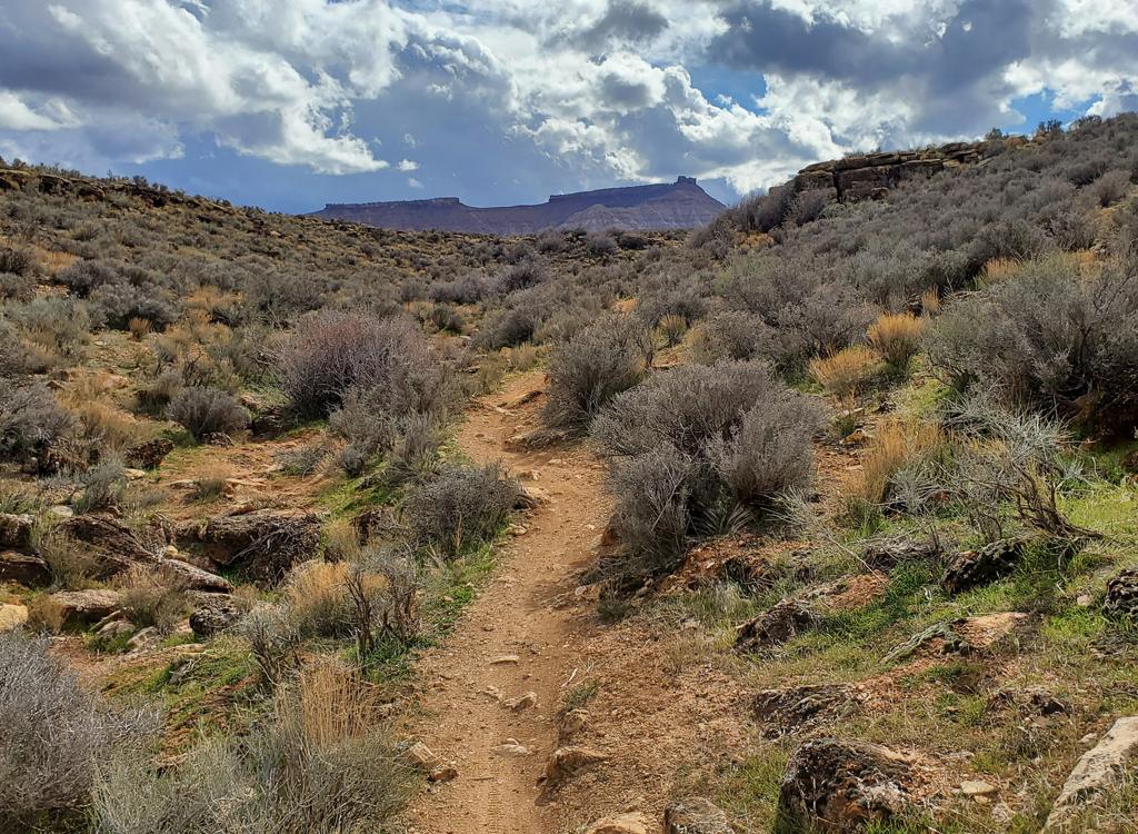

View west as we're climbing clockwise around the loop. We're just getting started. Bruce and Jackie hit this loop January 10, 2008. Latest update November 2019.
Barrel Roll Trail
The Barrel Roll Trail is an intermediate-level trail in the Santa Clara River Preserve, just west of Santa Clara. It's a loop ride 6 miles in length. Starting elevation is 3100 feet, top 3500. The trail undulates up and down, making total climbing around 700. You'll like this ride. It's quick and close to civilization, not too brutal, with nice views.
The Barrel Roll Trail is an intermediate-level trail in the Santa Clara River Preserve, just west of Santa Clara. It's a loop ride 6 miles in length. Starting elevation is 3100 feet, top 3500. The trail undulates up and down, making total climbing around 700. You'll like this ride. It's quick and close to civilization, not too brutal, with nice views.
While most of the trail is easy cruising, easily done by an experienced beginner, there are
some significant challenges. All but expert-experts will walk a couple
of the rock challenges.

Bruce fights up a series of ledges on the return side of the loop. Just throwing this picture here early on, so you don't think it's all noob-level cruising.

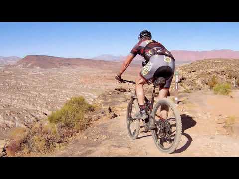
Heading down a particularly tricky series of rock challenges on the far west side of the loop. There's a stretch of around 100 yards here -- a spooky series of drops then a tricky climb with forward-facing ledges -- that I've never, ever, not once, ridden without at least one dab.
Barrel Roll shares the Cove Wash trailhead just outside Santa Clara with the
Rim
Rock
,
Sidewinder
, and
Suicidal
Tendencies
trails. (Black Brush is a foot and horse trail.)
Navigation is straight-forward. Forks are plainly marked. Just ride to the start of the loop
0.1 miles from the trailhead, and decide which way you want to ride. I
like clockwise, because
it puts a couple of tricky rock stunts on the downhill. If you like a
challenge, ride the loop
both directions to see if you can clear everything both up and down.

As we gain a little altitude, we see inspiring views to the north. Above Santa Clara and Ivins rise red cliffs of red Navajo sandstone from the Jurassic Period fronting white cliffs also of Navajo. In the middle are cinder cones from lava eruptions of about a million years ago, with the Pine Valley Mountains (volcanic granite) in the background. It's January, and it's a beautiful day for riding.

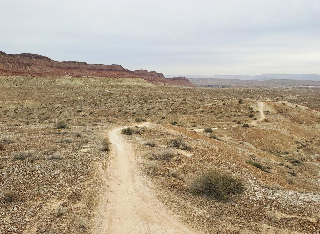
To the south, mesas of the Chinle formation are formed of erosion-resistant caprock lying on skirts of softer red mudstone and clay.
As the trail winds around the mountain, you'll have some great views of mesas and eroded badlands.
To the north, the volcanic Pine Valley Mountains dominate the sky above
cliffs of Navajo sandstone.
In the spring, prickly pear, cholla, and barrel cactus are in bloom. For
a desert, there's
a surprising amount of eye candy here.
Long stretches of the trail are pretty smooth. Some spots have a lot of protruding rock obstacles
and ledges. There's red dirt, white dirt, sandstone, conglomerate, and
the occasional chunk
of basalt.

Ah, we're near the top, and the fun begins. We're about to thread through some tricky rocks with the cliff about 5 feet away, then hit a rock ramp that ends in a nice high ledge with a waterfall drop.

Bruce hits a notorious drop on the far side of Barrel Roll. It's OK to walk this section. Almost everybody does.
While most of the trail is easy cruising, easily done by an experienced beginner, there are
some significant challenges. All but expert-experts will walk a couple
of the rock challenges.
Some buff riders want to connect to this trail, on dirt, from St. George. It can be done. The
shortest route, from Green Valley, will add at least 12 round-trip miles
to your ride. First,
get to Stucki Springs. Then follow the Stucki Springs road north until
you hit the Preserve
turnoff. (There are other ways. See the GPX file.) Here are the usual
options:

The return trip has long stretches of twisty downhill. Many rock ramps have a roll-it line, and just a foot or two away, a huck-it line.

There are views everywhere, constantly changing. A grand vista of multiple parallel erosion tracks. Cloudbursts have created many deep chasms as water rushes toward the river.
1. Green Valley, 6.0 miles (plus city streets) each way:Up DH
section of GV racecourse (1.8 miles). In the DT dip at top, drop down
very-steep DT into the next valley, proceed west then northwest and
go through the fence to Stucki Springs (1.3 miles). R on Stucki Springs Rd
2.1 miles, left on preserve road, 0.8 to trailhead.
Green Valley alternate, 8.4 miles: Head up road to Bearclaw parking, continue on Bearclaw to Stucki ATV connector 1.4 miles after Bearclaw TH. Follow connector to Stucki springs, then follow the road. Advantage: avoid the hike-a-bike back up the bluff on the way back.
Green Valley alternate, 8.4 miles: Head up road to Bearclaw parking, continue on Bearclaw to Stucki ATV connector 1.4 miles after Bearclaw TH. Follow connector to Stucki springs, then follow the road. Advantage: avoid the hike-a-bike back up the bluff on the way back.
2. Bloomington, 8.8 miles (plus city streets) each way:
Follow Bearclaw through the roller coaster section, up acid drops, then
fork L on ATV-track to Stucki at mile 2.8. L when you hit the DT at 2.9
miles and proceed another 0.2 to Stucki Springs. Go through fence. R on
Stucki Springs Rd 2.1 miles, left on preserve road, 0.8 to trailhead.

You'll enjoy almost constant views of the red Kayenta Cliffs and the Pine Valley Mountains.

You will not regret riding Barrel Roll. It's quickly become a St.George classic.
Bloomington alternate 11.3 miles: On Bearclaw, instead of heading toward Clavicle Hill, head
northwest on the Stucki Springs trail. Follow it to the springs, then
hit the road. Advantage:
more miles, around 29 if you only do Barrel Roll once.
Riding guide, clockwise:
0.0 Enter Barrel Roll Trail (left)
0.1 Fork, go left. Gradual climb
0.6 Views to the left off cliffs
0.8 Keep straight (L=Sidewinder)
0.9 First crest, descend
1.1 Cross cattleguard in fence (R=shortcut). Begin climbing again
2.3 High point of ride
2.4 Furthest west, some tech fun here
3.0 Views of gorge of Santa Clara
3.1 Note Black Brush trail below you
3.4 Trail turns at end of canyon
3.6 Just a bit away from outgoing trail here
4.2 Gate in fence
4.5 Turn in canyon, not too far from cattleguard. Cruising faster now
5.9 Back at fork
6.0 Parking

Photo: Don't hit these with your foot. They're not nice. Ride in control.

Getting there:
Cove Wash trailhead: In St. George, head north on Bluff Street and turn left on Sunset Blvd. Drive 3 miles west on Sunset through Santa Clara. As you're reaching the end of Santa Clara, look for a road crossing the river on your left. It's about 200 feet before the Jacob Hamblin Home (which will be on your right if you pass the turn). Turn and cross the river and follow the road as it turns right. About 0.4 miles from Hwy 191, turn left onto the dirt Stucki Springs road as it climbs steeply south. At mile 0.7, turn right at the sign "Santa Clara Preserve" or "Cove Wash Trailhead." Pass the water tank, and at mile 1.3, turn right again through the fence. This road will veer left to a log-fence parking area at mile 1.5, N37 07.253 W113 40.508.
From downhill by bike: There's a singletrack trail you can ride from the valley to the trailhead. After crossing the river and following the road as it turns right, pass the dirt Stucki Springs road. About 100 feet past the road, a doubletrack heads obliquely westward uphill on the left, turning quickly into singletrack heading up along the wash. at about 1/3 mile, keep R at the fork (L rejoins the road). The trail will climb up and west of the water tank, then join the road right at the fence of the preserve.
Riding resources for this trail:
Single-page riding guide GPS track files (right-click and "Save as..."):
Barrel Roll Only
Area multi-track file
Connect via Green Valley 5 options
High-res topo maps for printing:
View full area topo
Smaller topo
Lodging, camping, shops: Links to St. George area resources
Single-page riding guide GPS track files (right-click and "Save as..."):
Barrel Roll Only
Area multi-track file
Connect via Green Valley 5 options
High-res topo maps for printing:
View full area topo
Smaller topo
Lodging, camping, shops: Links to St. George area resources