
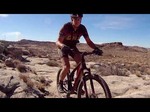

Looking west as Bruce navigates the badlands along the Green River. Photos and review March 19, 2018.
Athena Trail
The Athena trail lies just southeast of the city of Green River. This 5.5 mile loop is for experienced intermediate to advanced riders. The usual riding season will be March through November. Aerobically, it's a fairly easy ride. There's a bit of up-and-down as the trail twists through badland canyons, adding up to 600 vertical feet per lap. But there are no prolonged climbs.
The Athena trail lies just southeast of the city of Green River. This 5.5 mile loop is for experienced intermediate to advanced riders. The usual riding season will be March through November. Aerobically, it's a fairly easy ride. There's a bit of up-and-down as the trail twists through badland canyons, adding up to 600 vertical feet per lap. But there are no prolonged climbs.
It's hard to describe the "character" of this ride. It's like a bunch of rides tossed into
a blender. In a fun way. There's a lot of up-and-down, a bit of slope-hugging,
a bit of open
slickrock, a bit of crank-across-the-desert.
The trail passes through an unusual colorful badland area. Eye candy in the Morrison Formation from the late Jurassic. You'll ride through slopes of bright white, deep purple, orange, brown, and even green. And there are views of the Book Cliffs, the San Rafael Reef, and the Green River.
The trail passes through an unusual colorful badland area. Eye candy in the Morrison Formation from the late Jurassic. You'll ride through slopes of bright white, deep purple, orange, brown, and even green. And there are views of the Book Cliffs, the San Rafael Reef, and the Green River.

Zipping down through some chunky stuff as clay gives way to sandstone.

Hugging the purple side-slope of a small mesa.
The Athena trail was opened in March 2018. At the time of this review -- two days after the
trail was opened -- it rides nicely. But there's the typical "new trail
stuff" of loose dirt
and rough spots. It will be awesome when it's all packed in.
The Athena trail is named after the Athena missile, which was based in this area during the early days of the Cold War. Signs of the old missile base include the checkerboard of concrete tent pads along the road to the trailhead.
The Athena trail is named after the Athena missile, which was based in this area during the early days of the Cold War. Signs of the old missile base include the checkerboard of concrete tent pads along the road to the trailhead.
The Athena trailhead is less than a mile off the I-70 freeway, just east of the Green River.
This makes the Athena trail an ideal fading-light ride on your way to
Moab. (There are a lot
of great rides in the Green River area -- but by the time you've done
25 miles of dirt road
to get there, you could already be in Moab. Being right outside of town,
the Athena trail is
a sign of great things to come in Green River.)

Looking north over the trailhead parking, with a water tank of the town of Green River and the Book Cliffs in the background.

Nearing the top of the first climb out of the valley on the counterclockwise ride.
Don't let the blah gray dirt of the trailhead area fool you. After seeing mile after mile of
gray Mancos Shale during the drive to Green River, you could be forgiven
if you thought that's
all there was. But at the Athena trail, all the ugly of the whole ride
is stuffed into the
first half mile. Then things get psychedelic.
The trail forks immediately upon leaving the fenced parking area. I rode the loop counterclockwise
by keeping to the right. A lot of the features "felt" like this was the
direction to go.
After you warm up on that half-mile of sagebrush, climb to the overlook above the Green River. Here the singletrack temporarily joins an old doubletrack as it approaches the cliffs. When the singletrack veers to the right away from the doubletrack, consider taking a detour on that doubletrack 1/10th mile to the overlook in the photo.
After you warm up on that half-mile of sagebrush, climb to the overlook above the Green River. Here the singletrack temporarily joins an old doubletrack as it approaches the cliffs. When the singletrack veers to the right away from the doubletrack, consider taking a detour on that doubletrack 1/10th mile to the overlook in the photo.

View over the Green River, reached via a short doubletrack spur.

Descending southbound as the trail follows a band of sandstone in the clay.
Once you pedal away from the river overlook, you'll begin a series of twisting descents and
climbs. It will seem like each one lies in a different type of mudstone
or clay. Purple. Green.
Brown. Orange. Some of the riding is easy; some is hard.
If you can slow down enough to look, there are views from the top of each little mesa you cross.
You'll have glimpses of the Book Cliffs to the north, and of the teeth
of the San Rafael Reef
in the distance to the west.

Cresting another little hill, ready to descend again. The Book Cliffs are in the background. Below them is the town of Green River.

Heading east way from the slickrock area.
On the far west side of the loop, you'll find some slickrock. Not a lot. I believe this is
Salt Wash sandstone. But the terrain changes so quickly, I'm not sure
about that.
After the flattish area of slickrock, it's back to canyons and changing colors of shale and mudstone as you curve back towards the trailhead.
After the flattish area of slickrock, it's back to canyons and changing colors of shale and mudstone as you curve back towards the trailhead.
Bottom Line!
Definitely worth doing. This trail is going to be awesome when it's all packed down and ridden in. But don't wait. Add the Athena trail to your plans.
Definitely worth doing. This trail is going to be awesome when it's all packed down and ridden in. But don't wait. Add the Athena trail to your plans.

Dropping a ramp in this drone view.

Athena Trail map
Getting there:
On I-70 eastbound, take the second (east) Green River exit. Turn right at the off-ramp's stop sign, then immediately right again at the T intersection. Drive 1/3 mile west. Turn hard left on a gravel road. Drive past the concrete pads of old "tent city" and about 150 yards later, turn right into the parking area.
On I-70 eastbound, take the second (east) Green River exit. Turn right at the off-ramp's stop sign, then immediately right again at the T intersection. Drive 1/3 mile west. Turn hard left on a gravel road. Drive past the concrete pads of old "tent city" and about 150 yards later, turn right into the parking area.
No water or bathroom at trailhead.
Camping at the Green River State Park, 2 miles away.
(Two commercial RV campgrounds in Green River)
Hint: Motels are much cheaper here than in Moab. I like to play away the afternoon in the Green River area and stay in town for the night. My favorite eating spot is Ray's. Then I head for Moab early the next morning.
Riding resources:
GPS track file (right-click and select "Save Target as..."): GPX track file
View map for printing: High-Res Aerial
Lodging, camping, shops:
Links to Moab area resources
Links to Price area resources
GPS track file (right-click and select "Save Target as..."): GPX track file
View map for printing: High-Res Aerial
Lodging, camping, shops:
Links to Moab area resources
Links to Price area resources


