
")
Typical bermed turn designed for high-velocity, high-G change of direction. Rail it! Trail review by Bruce, September 2008. Photos September-October, 2008. Latest information update December 2017.
Maple Hollow DH
The Maple Hollow DH route is two miles of hard-core stuff. It drops from the Maple Hollow trailhead on Deer Ridge of Traverse Mountain down to just below Traverse Ridge Road near the Bonneville Shoreline trail. There's around 1000 vertical feet of elevation loss. As the "DH" should tell you, it's one-way downhill-only.
The Maple Hollow DH route is two miles of hard-core stuff. It drops from the Maple Hollow trailhead on Deer Ridge of Traverse Mountain down to just below Traverse Ridge Road near the Bonneville Shoreline trail. There's around 1000 vertical feet of elevation loss. As the "DH" should tell you, it's one-way downhill-only.
This trail is for expert riders. You don't need a DH-specific bike, but you need the skills
and brass to take some steep drops and high-G turns. The turns are sloped
for aggressive riders.
Intermediates will struggle on this trail, because many turns won't let
you "mosey on around"
-- you've got to rail it.

Here the trail splits into two bermed turns leading either into a dirt jump (A-line for air-cravers), or a simple drop through the dip and up into a banked turn (B-line for XC types).

As riders fall away from the banked turn above, experts should keep enough speed to gap-jump up onto a higher A-line. Non-jumpers and slower riders will veer onto a lower line.
Yes, there's a B-line to skip most jumps. With good skills, you can enjoy swooping down the
trail. You don't have to be a jumper. But if you're anything but an expert
rider, please stay
away.
The trail starts at the Maple Hollow trailhead (at the west end of the mountaintop Suncrest
subdivision) where Deer Ridge Drive meets Elk Glen Drive. It plunges 1000
vertical feet in
two miles. Most stunts have an A-line for the hardcore and a B-line for
the merely skilled.

The step-up in action. Above, leaving the launch.

Landing the bike on the higher trail.
In shaded forest areas, the soil gets pretty slimy after a rainstorm. This trail will be highly
dangerous when wet. Big tires, aggressive knobs, low center of gravity.
This trail will be closed during early spring and late fall when the surface is soft. Do NOT
poach this trail during off-season or when temporarily closed due to storms.
Check Draper's
recreation website for closure status.

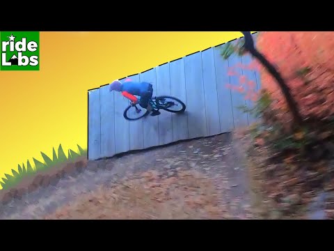
This tabletop jump clears 8 feet. Launch the upside, land the downside. If you fall short, there's the tabletop to land on. The B-line (to your right) skirts the jump, but offers a little lip to jump off, if you like.

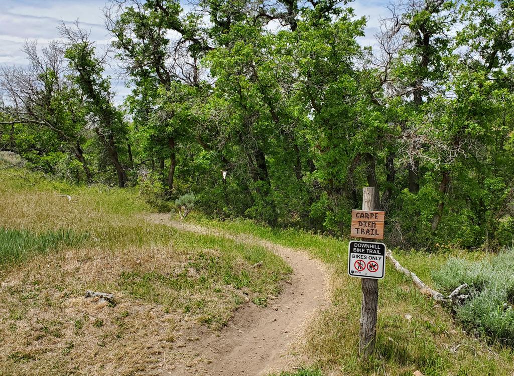
This ladder marks the official entry into the DH area. There's wheelie-drop off the ladder, then a whoop-de-doo down a short gulley.
This trail will continue to evolve as stunts are worked over and structures age. So you may
not see the exact features that are shown on this web page.
Note that the nearby Oak Hollow trail is NOT part of the downhill route! Oak Hollow is a multi-use
trail, and it upsets some trail users when they encounter fast-moving
armor-plated riders on
Oak Hollow. They complain to Draper City, and it causes trouble for the
people who build and
maintain the trails. Your shuttled DH ride should end at Traverse Ridge
Road.

Stunts are being added as the trail matures. Here's a rock with a couple of feet of air on the downside.

Lower parking area. The trail from the BST is behind the camera. (At the south end, a doubletrack descends to the golf course, intercepting the Oak Hollow trail, but it's not a route you'd want to take as your climb back to the parking lot.)
The trail finishes on Traverse Ridge Road. Don't cross the road. Instead turn to the left (west
downhill) on the trail that runs parallel to the road. Cross a subdivision
road, then find
the singletrack dropping steeply into the ravine. When the trail joins
the BST (Bonneville
Shoreline Trail) in the bottom of the ravine, make a hard right turn to
go downhill to the
underpass under the road. As you exit the tunnel, turn left. Immediately
fork L again on the
uphill trail. (The left downhill fork is the Oak Hollow trail down to
the pool area.) After
1/10th mile, the trail will reach the north side of Traverse Ridge Road.
Now keep straight
and coast down to the fenced parking area.
Notes on the Maple Hollow DH trail:
0.0 West from TH, keep R at Ann's Connector
0.3 Cross DT N40 28.593 W111 51.156
0.5 R for entry into DH N40 28.634 W111 51.343
1.9 R (straight = old Maple Hollow)
2.1 Traverse Ridge Rd, L along road
N40 29.081 W111 51.856
Cross subdivision road
2.2 Drop into ravine, hard R on BST
Through tunnel, then full L uphill
R = BST, mid-L = Oak Hollow
2.3 Straight to parking

After a steep plunge, these two pop-up ramps await.

Trail map
Getting there, Maple Hollow (Deer Ridge) trailhead:
From I-15
in Salt Lake City, take the Bluffdale exit and head east on Highland Drive
toward the mountains. As you reach the traffic light at the top of the
hill, about 3/4 mile after leaving the freeway, turn right on Traverse
Ridge Road. Drive about two miles up to the top of the mountain. At the
stop sign in Suncrest, turn right on Deer Ridge Drive and go 0.9 miles.
Just before the road crosses a bridge, turn right onto Elk Glen Drive and
immediately turn left to park at the small picnic area. The Suncrest Loop
Trail starts with the cinder path on your left. The Maple Hollow DH trail
is straight ahead and veers to the right toward the Salt Lake valley.
Shuttle vehicle, Oak Hollow (Traverse Mountain Road): Leave your vehicle at the fenced parking area on the north side of Traverse Ridge road, about a mile uphill from Highland Blvd. The trail will come into the east (uphill) side of the parking lot, from the underpass where the BST crosses under Traverse Ridge Road. [Important: Use the official trailhead. Cars parked along the road may be ticketed!!!]
Shuttle vehicle, Oak Hollow (Traverse Mountain Road): Leave your vehicle at the fenced parking area on the north side of Traverse Ridge road, about a mile uphill from Highland Blvd. The trail will come into the east (uphill) side of the parking lot, from the underpass where the BST crosses under Traverse Ridge Road. [Important: Use the official trailhead. Cars parked along the road may be ticketed!!!]
Riding Resources:
GPS Files, incl. Draper trails (Right-click and "Save as..."):
GPX
Large-format topo regional map: View
Lodging, camping, shops: Links to southern SLC resources
GPS Files, incl. Draper trails (Right-click and "Save as..."):
GPX
Large-format topo regional map: View
Lodging, camping, shops: Links to southern SLC resources